Douglas County Sheriff’s office provides details on drone program; drone has been deployed 46 times so far
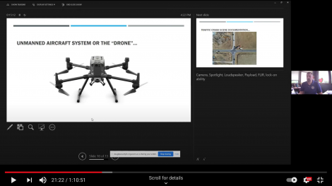
photo by: Douglas County
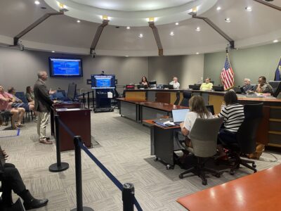
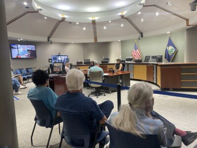
Douglas County Sheriff Jay Armbrister gives a presentation to the Douglas County Commission about the Sheriff's Office drone.
Sheriff Jay Armbrister says he realizes the idea of a law enforcement agency operating a drone over the skies of Douglas County could make people uncomfortable, and he says that’s why the sheriff’s office is trying to be upfront about its drone program and how it’s being used.
The Douglas County Sheriff’s Office began the program in December and has since used the drone 46 times, including to help catch a fleeing suspect, document the scenes of traffic accidents and aid in fire-fighting strategy, Armbrister said. He told the Journal-World that his office knows the public can view a drone as extremely intrusive and a possible violation of privacy, but that’s not what the program is about.
“That’s why we are showing what we use it for and how we use it,” Armbrister said. “This way we can be upfront and transparent so we can hopefully quell any worries the public may have.”
At the Douglas County Commission’s most recent meeting, Armbrister gave a presentation about the sheriff’s office that included information about the drone program. He told commissioners that the drone includes a camera that can zoom in on things, an infrared camera, a spotlight, a loudspeaker and a 10-pound carrying capacity, as well as the ability to lock onto and follow a particular vehicle or person.
“I’ve got a whole list of reasons that we (deployed) it, and it’s turned out to be an amazing tool,” Armbrister said.
Armbrister said in vehicle pursuits, once the drone’s camera is locked on a vehicle, it can continue to track it from the air. He said that allows law enforcement following the vehicle to back off enough that person thinks they are no longer being chased, which he said leads them to slow down and drive less recklessly and ultimately lowers the risk of the pursuit. The drone can then track the vehicle to its destination or could also follow an individual if they flee the vehicle and try to escape on foot. He said the drone had been used in a pursuit and the infrared ability helped deputies locate someone hiding in a field.
Another way it’s been used is to document accident scenes, replacing what Armbrister said is a time-consuming process of drawing detailed, scaled diagrams. He said it was also deployed in March during the fire at Babcock Place, a seven-story apartment complex, to help firefighters get a better view of the fire and where they needed to put their resources.
“They could see exactly where the fire was, where it was spreading, and where they needed to go to access it,” Armbrister said. He said the drone has since been used at other fires.
Commission Chair Shannon Portillo said she thought people in the community would have questions about the drone and some of the policies in place around its use. Portillo asked when and how the drone is accessed, what kind of training is required and what policies are in place.
Armbrister said deputies must be certified drone operators to use the drone and must follow FAA rules for when and how far the drone can be flown. That includes a rule that the operators can never let the drone leave their line of sight. He said the drone is a model that’s also available to the public, and that all of its equipment is locked in a cage at the Law Enforcement Center and is not put into use without a supervisor’s approval.
Commissioner Vice Chair Shannon Reid asked about how many people are trained to handle the drone and have access to it, and whether a detailed log of its use and who is operating it is kept. Armbrister said the sheriff’s office currently has four certified operators and is seeking to add two more, and that a detailed log is maintained.
Major Steve Buchholz later told the Journal-World that the drone is a Matrice 300RTK, manufactured by DJI, and that the drone, its associated equipment, and extra parts and batteries cost about $28,000.
The Sheriff’s Office also provided its policy for use of the drone to the Journal-World. The policy states in part that the main purpose of deploying the drone is to directly assist the Douglas County Sheriff’s Office in the prevention of crime, locating missing or endangered persons, the apprehension of criminals, the preservation of public peace, to aid investigations through video or mapping of scenes, and to protect the personal and property rights of the residents of Douglas County.
The policy goes on to state that a drone may be deployed for uses relating to but not limited to: search and rescue operations; accident reconstruction; crime scene photography, surveillance and documentation; mapping and modeling of critical infrastructure and pre-event mapping for planning large scale public events; and situational awareness, intelligence and support for tactical operations. A drone may also be deployed for other purposes where appropriate if approved by a division captain, according to the policy.
A list of general responsibilities for drone operators is also included. It specifies that operators must make an on-scene evaluation of each situation to determine whether it justifies deployment of the drone, which must include the “extent and manner” in which the drone is used. Each use of the drone must also be documented.
Buchholz said thus far the most common uses of the drone have been traffic accidents and crime scene investigations. He said as the weather gets warmer, he also expects it could be used to locate or assist lost or missing hikers or boaters at the area’s lakes and trails. He said the loudspeaker could also be used to make safety announcements, such as following a tornado.
Buchholz also spoke to any potential privacy concerns, saying the sheriff’s office does not use the drone for patrol purposes or just to survey neighborhoods. He said if the drone is deployed, it’s done for a specific reason and in line with the policy.
City Government

With city leaders’ approval, Lawrence Public Library’s outdoor pavilion should soon be under construction
Sustainability board wants the environment to be ‘an underpinning’ of Lawrence’s next strategic plan

AG Kobach warns Lawrence, 2 other Kansas cities to repeal their bans on conversion therapy within 60 days

Polian thinks Lawrence City Commission can still find consensus on forensic audit of capital projects
Potential ballot question on directly elected mayor needs much more discussion, Lawrence city commissioners say