Missouri residents prepare for high waters from flooded river
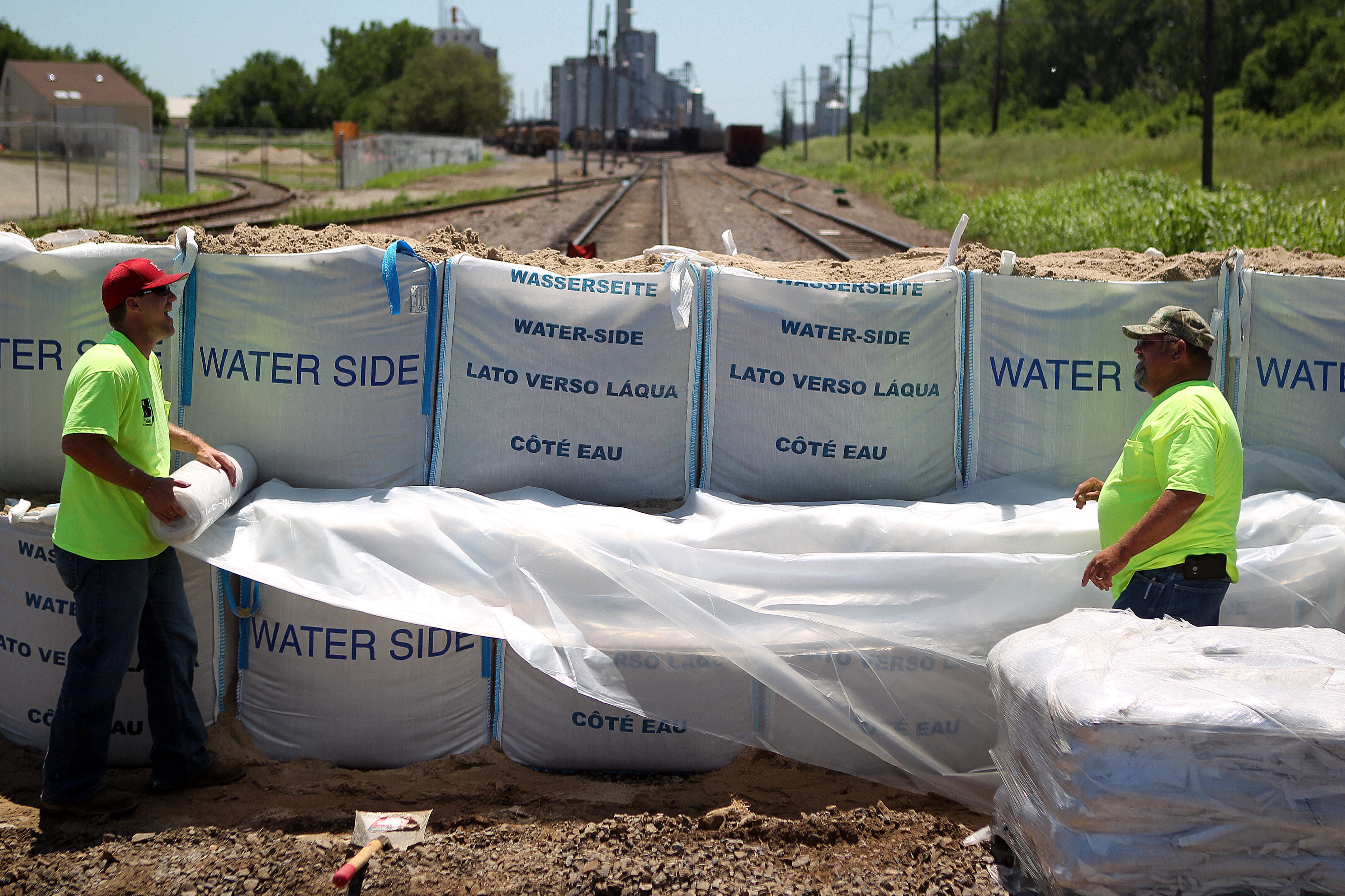
City employees spread plastic across the length of a sandbag levee they built to bridge a gap in an earthen levee across train tracks behind Artesian Ice in St. Joseph, Mo., June 28, 2011. The temporary levee is necessary to protect south St. Joseph from the rapidly rising Missouri River.

Ron Bachman, owner of St. Joseph Petroleum in St. Joseph, Mo., wades through Missouri River floodwaters to inspect his property Tuesday, June 28, 2011. Bachman was able to move his business to other locations because of the advance warning of the high water.

Tim Hogan pulls a jon boat behind his jet ski as he floats past cars owned by Terrible's Casino employees who couldn't move them before flood waters surrounded them Tuesday morning, June 28, 2011, in St. Joseph, Mo. Hogan was going to his rental home on the banks of the river to retrieve what he could from the flooded property.
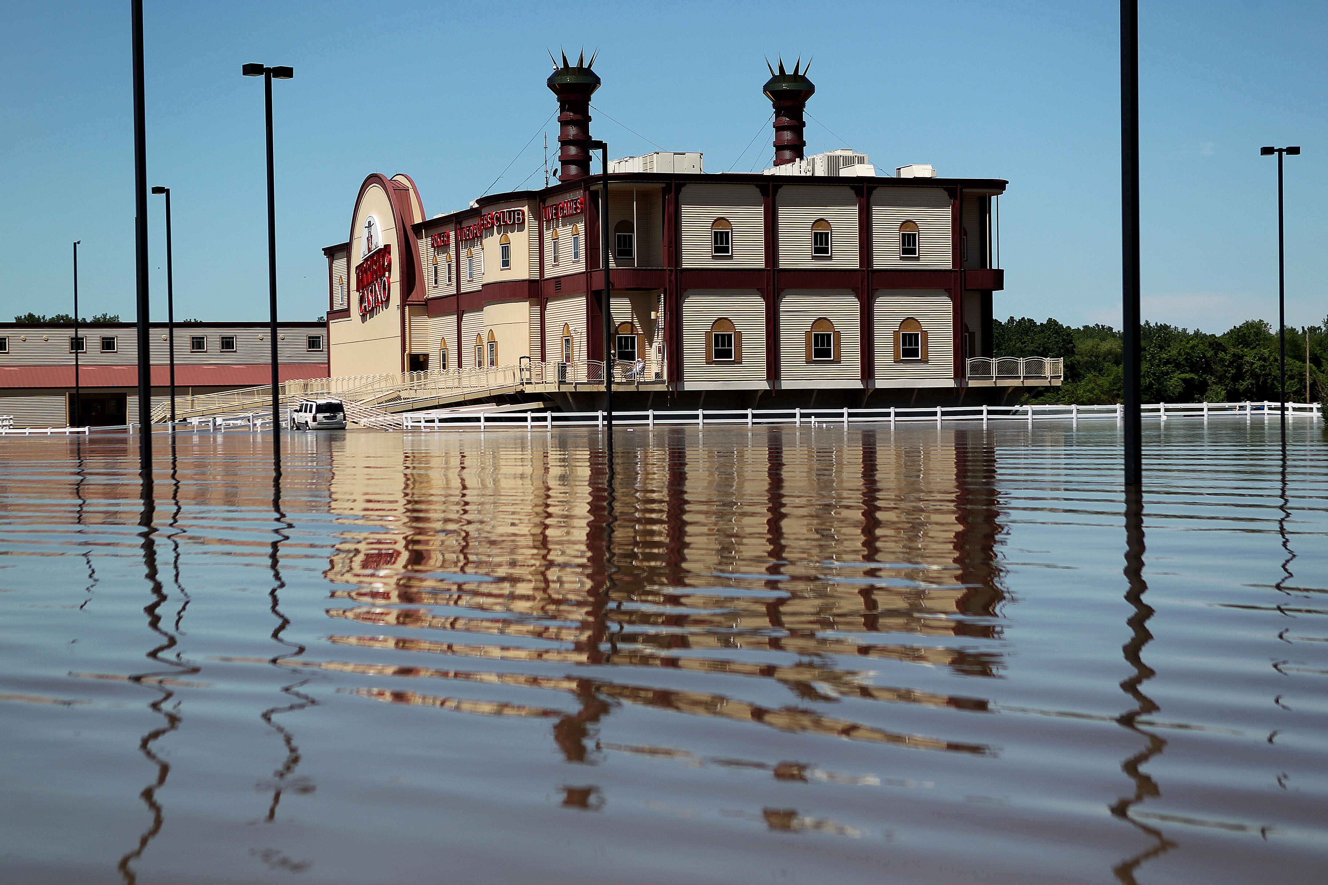
Terrible's St. Jo Frontier Casino is surrounded by floodwaters Tuesday, June 28, 2011, in St. Joseph, Mo. The casino has been closed indefinitely after its parking lot flooded and water went above a boat dock on the backside of the lot.
Kansas City, Mo. ? The Missouri River, distended from weeks of record releases out of upstream dams and recent rain, has pushed its way into Missouri, flooding riverfront farmland and towns, displacing hundreds of residents and raising concern in cities and towns further downstream.
“It has hit,” said Gia McFarlane, spokeswoman for Parkville, a town of about 5,000 located along the Missouri River north of Kansas City. “The park is inundated. The water comes up quite a bit seemingly every day. Right now it’s just filling the low-lying area.”
Parkville, which had prepared for the high water for weeks, closed its riverfront English Landing Park, but roads into Parkville and all of its businesses remained open, McFarlane said Wednesday. She said the town was also preparing for the possibility of higher water along the river in the coming days.
The Missouri River has been rising for weeks because of heavy rains and snow melt along the river’s headwaters, forcing the U.S. Army Corps of Engineers to open flood gates, sending massive amounts of water downstream along the Missouri River system. The corps has recently been releasing water at a rate of about 160,000 cubic feet per second at Gavins Point Dam in South Dakota. The corps planned to continue releasing water at that rate until at least August.
“We had originally planned for them releasing 150,000 cfs, and now they’re doing 160,000 cfs, and we’re trying to figure out what that means,” McFarlane said. “Every day the Army Corps of Engineers gives us different predictions because with rain it changes, and if a levee breaks it changes. Right now we’re trying to prepare for the worst and hope for the best.”
So far, about 600 people have been evacuated from several small towns along the river in northwest Missouri, according to the Missouri National Guard. The river, which moves south along the Kansas border to Kansas City where it veers eastward toward St. Louis, was expected to remain well above flood stage in some sections of the state for weeks.
Because of the flooding and road closures, particularly in northwest Missouri, Missouri transportation officials have extended permission for truckers to carry heavier-than-normal loads of livestock, grain, sand and gravel on some roads. The Missouri Department of Transportation granted a similar weight exception earlier this year when floods affected southern parts of the state, particularly along the Mississippi River.
Tom White, emergency management director for Cooper County in central Missouri, said the county had about 60,000 sandbags and loads of plastic sheeting standing by and that crews have also been working for weeks to reinforce a private levee protecting the small town of Wooldridge.
Boonville wouldn’t be affected until the river reached about 31.7 feet, White said. The river was at about 26 feet there early Wednesday, but it has been difficult to know what to expect because of changes in the river’s forecast, he said.
“The levees are failing, breaching, overtopping upstream,” White said. “It’s sad for them, but it’s having a positive effect on us because the river’s not going up.” The county has so far been prepared, but White said it was important for residents to remain on their guard.
“With the massive amounts of water being released. . . We’re going into areas we’ve never seen before,” he said. “This has been such a buildup. But we don’t want people to be lulled into a false sense of security.”
In Jefferson City, many business owners on the capital’s north side of the river — which was swamped by floodwaters in 1993 and 1995 — have made evacuation plans in case the river overtops a levee. But that appeared unlikely, at least in the short term.
The levee protecting north Jefferson City, including its airport, can hold back the Missouri River up to a level of a little more than 30 feet. After heavy rains Sunday night and Monday, the National Weather Service had forecast the river to crest at 29.4 feet on Friday. By Wednesday morning, that crest had been revised to less than 28 feet.
In eastern Missouri, the Mississippi River has also been spiking, but Fourth of July weekend events along the river have been largely unaffected.
The river had fallen to flood stage of 16 feet in Hannibal before heavy rains caused it to rise back to 20.6 feet Tuesday. The water was receding Wednesday, and the National Weather Service projected no significant flooding for the upcoming National Tom Sawyer Days, Hannibal’s most popular event.
The river was at 37.6 feet in Cape Girardeau in southeast Missouri on Wednesday, 5.6 feet above flood stage, and expected to rise to 40.3 feet on Sunday. Cape Girardeau is protected by a floodwall and no major problems were expected.
State Government

‘If it ain’t broke, don’t fix it’: Retired Judge Sally Pokorny tells residents why she opposes electing Supreme Court justices

KU professors would be limited in how they could present the idea of systemic racism in future classes
State legislators push back against federal energy regulators ending competitive bids
TOPEKA — Two Kansas legislators asked federal energy regulators to ensure competitive bidding occurs on ...
Senate confirms 1st of 3 Kansas nominees to U.S. District Court
Corporate income tax collections falling sharply in Kansas; Republican, Democratic leaders disagree on what it means
TOPEKA — Corporate income tax collections in Kansas have almost halved since last year, while other sources trend ...
Candidate’s campaign manager created website with documents used to attack rival
TOPEKA — Kansas U.S. Senate candidate Patrick Schmidt’s campaign manager left his digital footprint on ...