New details emerge on twisters’ power
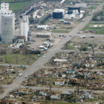
Tornado damage is seen in Greensburg in this May 5, 2007, file photo. Most of the southwest Kansas town was destroyed by a tornado that hit the previous night. A new study has found that more tornadoes were part of that outbreak than originally thought, and that some were unusually strong.
Wichita ? A study of the Greensburg tornado has found that the state saw more twisters that night than initially thought and that some of the tornadoes were unusually strong.
The twister that nearly wiped out Greensburg was one of 22 that touched down in southern and central Kansas from the same thunderstorm complex the night of May 4, 2007, and early the next morning.
That’s more tornadoes than initially thought, said Mike Umscheid, co-author of the first in-depth study of the Greensburg tornado and the meteorologist who issued the “tornado emergency” warning that night for the Dodge City branch of the National Weather Service. A handful of small tornadoes rotating around larger twisters initially went unnoticed.
Four of the tornadoes — in Greensburg and near Trousdale, Hopewell and Macksville — were particularly large.
Research shows the Greensburg tornado, which killed 11 people, had EF-3 or stronger damage in a track at least a mile wide, at least double the width of a tornado that struck Moore, Okla., and other suburbs of Oklahoma City on May 3, 1999.
“When you compare the two damage paths, there’s really not much comparison,” Umscheid said.
After destroying 95 percent of Greensburg, the tornado continued north, then curled west and looped back around, nearly striking the town a second time before lifting.
By then, the Trousdale tornado was already on the ground northeast of there. That twister grew to more than two miles wide and EF-3 strength.
While it was still on the ground, a third tornado touched down near Hopewell, killing Alex Giles on his farm. It grew to 1.3 miles wide and EF-3 strength. The Trousdale and Hopewell tornadoes were on the ground at the same time for nearly half an hour.
As the Hopewell tornado weakened, another large tornado touched down and tracked northeast, just east of Macksville, killing Stafford County Sheriff’s Deputy Tim Buckman.
Vortex holes
The Greensburg and Trousdale twisters were so intense the weather service’s radar in Dodge City detected vortex holes in them, something radar had never detected before, Umscheid said.
A vortex hole “is what you would see in the eye of a hurricane,” he said. The holes form when winds are rotating so rapidly they pull debris and even large raindrops from the center of the storm, he said.
The Trousdale tornado’s vortex hole was about two miles in diameter, not much smaller than the eye of Hurricane Charley, a Category 4 hurricane that hit Florida in 2004.
Researchers also saw something else they had never seen before: The mesocyclone — or “mother ship” cloud from which tornadoes develop — rotated as rapidly as the tornadoes. The Greensburg outbreak’s mesocyclones rotated so rapidly it was hard to distinguish them from the tornadoes on radar, the researchers said.
“The intensity of the radar-observed vortex is probably greater than any we’ve ever observed before,” said Les Lemon, a co-author of the study and research associate meteorologist with the Cooperative Institute for Mesoscale Meteorological Studies at the University of Oklahoma.
Uncharted waters
Mike Smith, founder and chief executive officer of WeatherData Inc., a private forecasting service based in Wichita, said that if the Trousdale tornado had hit a city, it likely would have been rated an EF-5.
“The thought of a tornado that size going through a major city scares me to death,” Smith said. “We’re in uncharted waters here. I don’t think we’ve ever seen anything like this on radar before.
“If you put a Trousdale-type tornado in the heart of Dallas or St. Louis, it’s going to take an emergency response more akin to a hurricane.”
State Government
‘If it ain’t broke, don’t fix it’: Retired Judge Sally Pokorny tells residents why she opposes electing Supreme Court justices
KU professors would be limited in how they could present the idea of systemic racism in future classes
State legislators push back against federal energy regulators ending competitive bids
TOPEKA — Two Kansas legislators asked federal energy regulators to ensure competitive bidding occurs on ...
Senate confirms 1st of 3 Kansas nominees to U.S. District Court
Corporate income tax collections falling sharply in Kansas; Republican, Democratic leaders disagree on what it means
TOPEKA — Corporate income tax collections in Kansas have almost halved since last year, while other sources trend ...
Candidate’s campaign manager created website with documents used to attack rival
TOPEKA — Kansas U.S. Senate candidate Patrick Schmidt’s campaign manager left his digital footprint on ...