April’s spike in storms marks busy start to the severe weather season in eastern Kansas
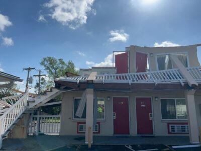
photo by: National Oceanic and Atmospheric Administration
The front of a two-story motel in Ottawa stands even after the exterior walls on the top story collapsed on Tuesday, April 14, 2026. The building was damaged by an EF2 tornado that struck the town Monday night, part of severe storms that caused several minor injuries across Kansas.
A tornado warning years ago forced Perry-Lecompton schools to keep students sheltered for 90 minutes after dismissal – and it has since left a lasting impression on Superintendent Josh Woodward.
It’s a situation the broader community still thinks about today, he said, even more so after eastern Kansas’ run in with severe weather the last couple of weeks.
When the threat of severe weather was upgraded to be basically inevitable on the afternoon of Friday, April 17, Perry-Lecompton and neighboring school districts – Lawrence and Baldwin City – immediately took action and let students and staff leave early. Eudora was the only school district not to.
The National Oceanic and Atmospheric Administration uses a five-level scale to forecast the probability of severe thunderstorms, large hail, damaging winds and tornadoes in the United States. That Friday, it was at a four-of-five for all of those severe weather risks.
“It’s still pretty rare, even here,” Matt Flanagan, a meteorologist with the National Weather Service office in Topeka, said, referring to the four-of-five risk issued that day. “I think once or twice a year is typically what we see.”
Woodward said one statement from weather broadcasters raised concern about the storms anticipated on April 17: “We haven’t seen conditions like this since the 2019 Linwood tornado,” an EF-4 tornado that also grazed Lawrence.
Much of Douglas County was also probably thinking about what just happened in Ottawa earlier that week, where an EF-2 tornado touched down, as the Journal-World reported. No one died from the event, but the rain-wrapped tornado produced significant damage across the city.
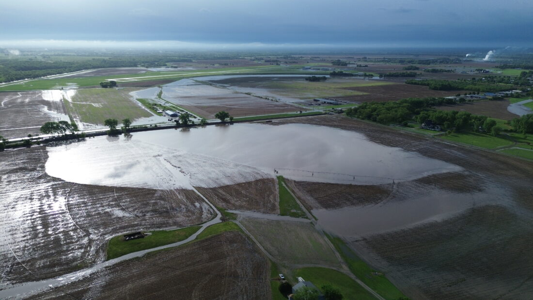
photo by: Submitted
Large amounts of standing water are visible near East 1400 Road, just south of the Midland Junction grain elevators, on April 27, 2026.
“Bottom line: we fully understood the forecast could be wrong and that we might have been able to finish the day as scheduled,” Woodward said via email. “However, had we kept students until 3:30, then sent them home on buses, or had high school students driving home with younger siblings, and those severe conditions developed, it would have been very difficult to justify the decision to keep students at school.”
Flanagan said it’s certainly been an interesting last couple of weeks, but he didn’t consider it to be completely unusual, as the time for severe weather in Kansas is typically from March into June – however, severe weather has been happening more frequently.
“This is our time of year that we expect severe weather, but maybe a little too frequent than we would like and more frequent than we’re used to,” Flanagan said.
While last week was generally quiet in Douglas County in terms of severe weather, the Journal-World counted at least 10 days in the month of April where Douglas County was forecasted to receive severe weather, averaging around two days per week.
“We’ve been in this busier pattern where we have the ingredients for severe thunderstorms more frequently than normal,” Flanagan said. “So usually, especially in the spring, you get a day or two of the ingredients (being) there for severe thunderstorms, and then, a stronger cold front comes through and pushes that risk out of the area.”
But, he said those severe weather ingredients have appeared again a lot quicker than what the National Weather Service is used to seeing.
In addition, Flanagan said there’s been a lot more rain than normal. Historical data has shown Lawrence to receive around 3.7 inches of rainfall in the month of April, and this year, April has reached 7.63 inches.
“It’s almost four inches above normal,” Flanagan said. “If you look at our climate record here in Topeka, the normal value is around 3.5 inches, and we’re at 6.36 inches … So yeah, definitely wetter, especially with a couple of events where we had two or three inches just coming in one day’s timeframe.”
As far as tornadoes go, Flanagan said the Topeka office’s forecast area – including major cities like Lawrence, Manhattan, Salina, Emporia and Ottawa – is on track to be an average or above-average year, where Kansas typically sees about 83 tornados per year.
The tornado activity has also probably caught some people off guard because 2025 was a below-average year for tornadoes, where there were only 32. He said there have been a total of six tornadoes so far in the office’s forecast area in 2026.
“If you go a bit farther east into places like Miami and Linn County, they’ve had a couple more tornadoes, and even some like Belton, Missouri, had a tornado, there’s one that went through Kansas City too,” Flanagan said. “So if you count all of those, roughly 10 or so, including our area, like eastern Kansas, northeast Kansas, and into the Kansas City metro.”
Even with that uptick across eastern Kansas and the Kansas City metro, meteorologists caution against drawing broad conclusions from a short stretch of active weather.
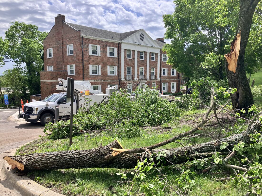
photo by: Kim Callahan/Journal-World
A tree is down near Pearson Hall on the University of Kansas campus on April 27, 2026.
State Climatologist Xiaomao Lin told the Journal-World via email that from a historical perspective, it is important to distinguish between individual events and long-term climate behavior. Single events – or even clusters of events over a few weeks – cannot be directly attributed to climate change.
“Instead, climate change is evaluated through long-term statistical trends in variables such as temperature, precipitation intensity, and atmospheric moisture,” Lin said in the email. “At the local scale, severe storm occurrence continues to show substantial year-to-year variability, making it challenging to identify clear trends in frequency, although changes in rainfall intensity and moisture availability are areas of active research.”
Despite the significant rainfall that has already occurred in the area this past month, a majority of the country is experiencing a severe spring drought, with over 52% of the contiguous United States in moderate to exceptional drought, according to the U.S. Drought Monitor.
“The recent precipitation can be beneficial for soil moisture recharge; however, excessive rainfall or repeated severe events may lead to localized flooding, planting delays, and soil structure concerns,” Lin said via email. “As we move into late spring and summer, crop outcomes will depend more strongly on the evolution of temperature, precipitation patterns, and atmospheric demand.”
During this time of year, Flanagan said sometimes it can be a little uncertain or challenging to determine if storms will develop, and whether they do or not, that can change the severe risk level.
“If a warning’s issued for your area, make sure you know what to do,” Flanagan said. “Whether it could be a day that we’re expecting widespread severe weather or a day we’re a little less confident in exactly how things are going to play out, it’s just best to have your plan in place.”
Other News

Big Boy, the world’s largest operating steam locomotive, is set to roar through Lawrence next week

From livestock shows to demolition derby: Douglas County Fair festivities return next week

State lifts health advisory for blue-green algae at Clinton Lake

Meet the 12 candidates seeking to unseat U.S. Sen. Roger Marshall in the upcoming primary

For Douglas County District 4, an incumbent commissioner and newcomer are vying for the seat