Worst of rain misses Lawrence; Corps starts discharge at Perry Lake
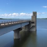
photo by: U.S. Army Corps of Engineers, Kansas City District/Contributed Photo
To ensure dam safety, the Kansas City District, U.S. Army Corps of Engineers planned to begin flood water releases from Perry Lake in Jefferson County beginning Sunday, May 26, 2019 as runoff from rains over the weekend were expected to fill the reservoir’s remaining storage capacity, according to a news release from the Corps.
Lawrence missed the worst of Saturday evening’s and Sunday morning’s rainfall, which produced as much as 1.5 unwelcome inches of rain in neighboring counties.
Jenifer Prieto, meteorologist with the National Weather Service office in Topeka, said 0.33 inches of rain were recorded overnight at Lawrence Municipal Airport, which was close to the 0.3 inches reported the night before. The Saturday evening/Sunday morning rainfall in Lawrence was much less than the 1 to 2 inches predicted.
“It failed to materialize,” Prieto said. “The heaviest rain was just to the west in southwest Shawnee County where they had a little over an inch. Northern Jefferson County had 1.5 inches as well.”
More rain was forecast for late Sunday and early Monday, but once again, Lawrence was expected to miss the heaviest rains. Prieto said it appeared the heaviest rains should fall north and west of Lawrence and Topeka. Weather was expected to clear Monday morning, and the next chance of rain will be Tuesday evening.
The Saturday night rains, coupled with the forecast for more rain, prompted the U.S. Army Corps of Engineers to announce it would start discharging water from Perry Lake at 6 p.m. Sunday. The release will start at 1,000 cubic feet per second and be stepped up to 10,000 cubic feet per second by Monday morning, according to a Corps news release.
The discharge is necessary because the lake’s level is expected to rise above its flood level of 920.6 feet above sea level by Wednesday. The news release states that discharges may have to be increased if more water continues to flow into the lake.
Prieto said the Topeka NWS office had received a report Sunday morning from Jefferson County Emergency Management of flooding in low-lying areas of Valley Falls caused by the backup of water in Perry Lake.
The Tuesday evening storm will be from typical Kansas spring supercell development, which will bring the chance of severe weather, Prieto said. Unlike the many recent storms that developed from a weather pattern of low pressure over the Rockies and a high-pressure dome over the U.S. Southeast, there will not be “trains” of thunderstorms associated with storms that develop Tuesday, she said. There could be spotty areas of heavy rains, but not a general soaker like those of the past six weeks.
The long-range forecast for northeastern Kansas suggests cooler than normal temperatures for early June with slightly above average rainfall, Prieto said. That appears to be a return to a more typical weather pattern with slightly more rain, she said.
Another lake upstream from Lawrence may also be forced to release more water. The Perry Lake Facebook page has video showing water at Tuttle Creek Lake north of Manhattan reaching the top of its as-yet closed spillway. Prieto said the water level at Tuttle Creek rose 1.4 feet in the last 24 hours from recent rains in the Blue River watershed.
Other News

Renovated Elsie’s Place opens as O’Connell Children’s Shelter marks 50th anniversary

Lawrence school district will soon implement changes to its cellphone, electronic devices policy to comply with state law

After an especially difficult year of trauma and bullying, a Lawrence teen gets a dream gift
Prairie Park’s artificial floating island is cleaning the water and hosting all kinds of wildlife

Farmland’s legacy: How what used to be the largest farmer-owned co-op left contaminated sites in Lawrence and beyond