

Lawrence Loop trail may go along busy downtown street; city wants to steer clear of Riverfront for development reasons
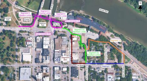
photo by: Screenshot
This image shows proposed route segments for the Lawrence Loop trail in downtown. A report from consultants says the orange and green segments aren't feasible.
Rather than bypassing downtown’s busiest streets by going along the railroad tracks and through the Riverfront Mall site, the Lawrence Loop trail might be routed down Seventh and New Hampshire streets.
That’s according to recommendations in a draft report from Trekk Design Group on how to close the downtown segment of the trail network, one of the few legs yet to be completed. The report is set to be discussed next week at a meeting of the Connected City Advisory Board.
As the Journal-World has reported, the city has spent months trying to determine how to connect the two ends of the Loop that border downtown: the Santa Fe Depot in the east and Constant Park in the west. In a survey the city conducted earlier this year, respondents strongly preferred keeping the Loop out of the heart of downtown. Most favored having the trail follow the railroad tracks northwest, passing through the Riverfront Mall site and then behind City Hall.
But while the alignment recommended by Trekk would still run behind City Hall, it wouldn’t go along the tracks or through the Riverfront site.
The report said that city management specifically asked that Riverfront not be considered for routing purposes because of potential future development there. The city will be taking over the building next year as part of a lawsuit settlement that it reached with the building’s owners, and city staff has proposed demolishing the structure and replacing it with new development of some sort.
Going along the railroad wouldn’t be feasible either, the report says, because without Riverfront being feasible, there’s nowhere a railroad route could connect to. It also says there could be right-of-way issues involving the BNSF Railroad and that there are steep slopes in the area, so building there would require walls and fencing, “impacting private properties and necessitating the removal of a significant number of existing trees.”
Instead, the report recommends routing the trail on Seventh Street and then along New Hampshire Street. From there, the trail would go around City Hall to the north or south – or both, to create a loop around the building – and then pass underneath the Kansas River bridges before reconnecting to Sixth Street and Constant Park.
In the survey earlier this year, a segment of the trail that would run along New Hampshire was the least popular idea that was proposed; out of hundreds of respondents, only 21 people said they supported the idea. Many respondents said inattentive drivers were too dangerous and that they wanted a completely separate path for bikes wherever possible.
The report from Trekk says that a route along Rhode Island Street was also assessed for feasibility, but that was before city management said the Riverfront site shouldn’t be pursued. “Given that the alignment through the One Riverfront Plaza Parking property has been deemed unfeasible, this segment will have no option to continue to the north and cannot be considered,” the report says.
Trekk also estimated the cost of building the Loop along the suggested route. The total estimated cost would be $1.8 million, it said; more than half of that would be for the portion that runs north of City Hall and under the bridges.
In a memo to the board, city staff said Lawrence has been awarded $1.23 million in federal grant funding for the project.
The Connected City Advisory Board will meet at 5:30 p.m. Monday at the Municipal Services and Operations campus, 1840 O’Connell Road, to review the report from Trekk and consider providing a recommendation to the City Commission. The meeting will also be available via Zoom.
City Government
As they approve bikes plan, Lawrence city leaders ask about data collection, Kentucky and Tennessee streets
Lawrence city leaders want to toughen tobacco licensing rules ‘sooner than later’
Algerian government invites Mayor Brad Finkeldei, Lawrence delegation for a visit
Construction on Wakarusa Drive to resume; city manager says KDOT’s secretary has apologized for delay
Evacuation drill planned Tuesday at Lawrence City Hall
