Ariz. wildfire threatens power transmission lines
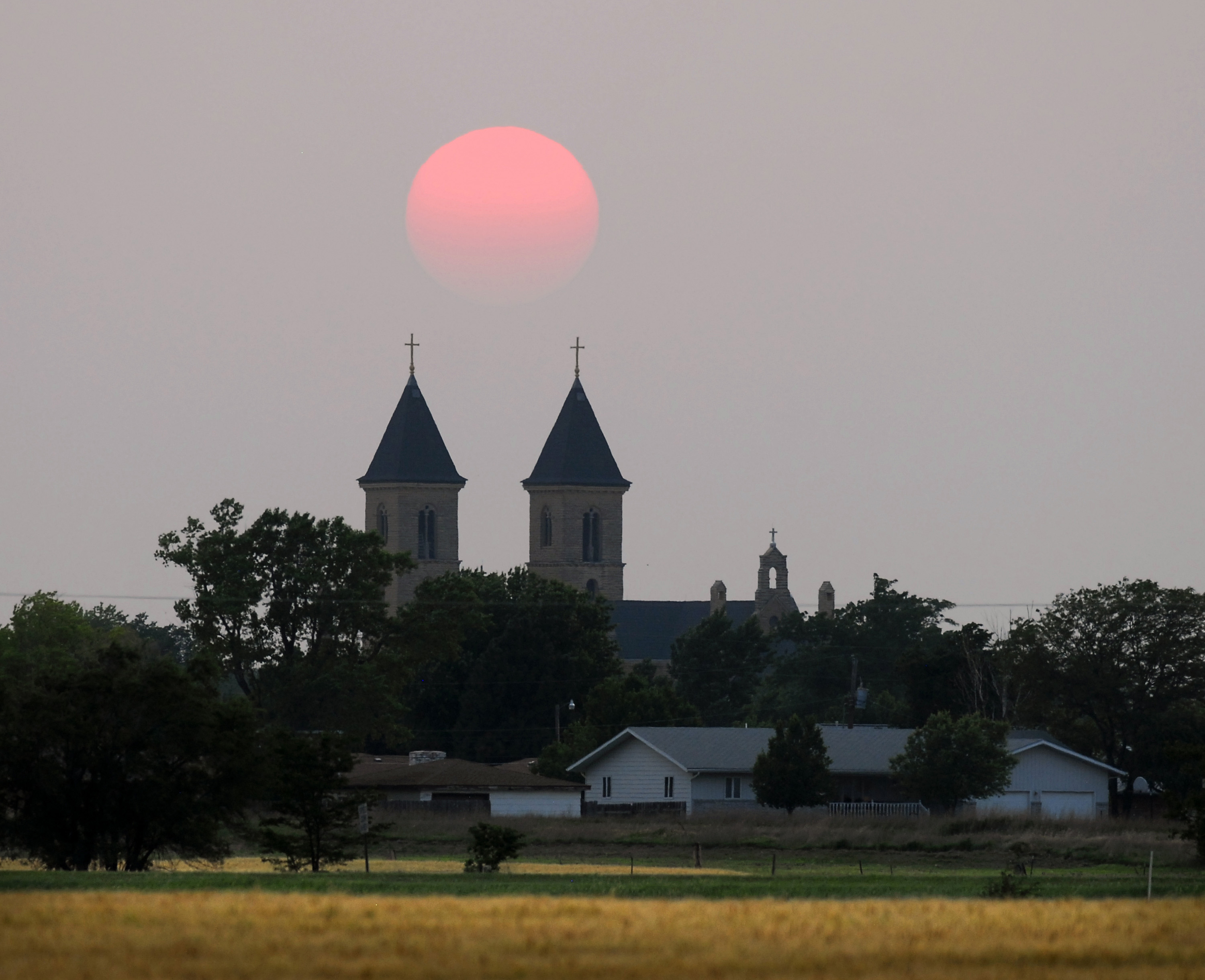
The sun is almost opacified by smoke that drifted over Kansas from wildfires in Arizona as it sets behind the Cathedral of the Plains Tuesday, June 7, 2011, in Victoria.
Springerville, Ariz. ? A raging forest fire in eastern Arizona that has forced thousands from their homes headed Wednesday for a pair of transmission lines that supply electricity to hundreds of thousands of people as far east as Texas.
The 607-square-mile blaze is expected to reach the power lines as early as Friday. If the lines are damaged, parts of New Mexico and Texas could face rolling blackouts.
For now, firefighters who have helped keep the flames away from several towns in eastern Arizona are concerned that high winds expected later Wednesday could carry embers that can cause new, smaller spot fires.
“We have a lot of people out there who are going to be doing nothing but looking for spots and putting those things out if they see them,” fire information officer Jim Whittington said.
The blaze has blackened about 389,000 acres and destroyed 11 buildings, primarily in the Apache-Sitgreaves National Forest. No serious injuries have been reported.
Fire crews had furiously worked to protect the town of Eagar and Springerville on Tuesday, and it appeared to pay off. They created barriers between the towns and the fire and burned out combustible material, such as brush and trees.
“It’s looking good to us. It did what the team said it would do when it came over the hill toward town,” Apache County Sheriff’s Office Chief Deputy Brannon Eagar said. He added: “It worked out perfectly.”
The fire prompted El Paso Electric to issue warnings of possible power interruptions for its customers in southern New Mexico and West Texas.
Texas-based El Paso Electric uses two high voltage lines to bring electricity from the Palo Verde Nuclear Generating Station west of Phoenix to the two states. Losing the lines would cut off about 40 percent of the utility’s supply, possibly triggering the rolling blackouts among its 372,000 customers.
Winds in the area were expected to gust up to 35 mph on Wednesday. Officials in Catron County, N.M., told residents of Luna to be prepared to leave if winds push the blaze into western New Mexico.
About half of the 4,000 residents who call Eagar home were forced to leave Tuesday as the fire licked the ridges surrounding the area. Those in neighboring Springerville worried as they awaited word of whether they too will have to flee.
“Everybody that’s here is suffering from anxiety from this,” Eagar told residents.
As daylight waned Tuesday, cars, trucks and trailers loaded with belongings streamed out of Eagar as sheriff’s deputies and police officers directed traffic. Flames dotted a ridge on the southeastern side of Springerville, and columns of orange smoke rose from the hills.
Ash rained from the smoke-filled sky. When the sun peeked through, it was blood-red.
Crews worked feverishly overnight to ignite unburned areas of grass and other fuel to starve the fire in case it burned over the ridge and into the grasslands and stands of trees that border the two towns.
The blaze, burning in mainly ponderosa pine forest, was sparked May 29 by what authorities believe was an unattended campfire. It became the second-largest in Arizona history on Tuesday.
It has cast smoke as far east as Iowa and forced some planes to divert from Albuquerque, N.M., some 200 miles away.
By late Tuesday, the flames were about two miles from Springerville and Eagar on the edge of the forest, fire officials said.
Firefighters were trying to protect the mountain towns of Alpine, Greer and Nutrioso. They were able to keep it out of the canyons surrounding the small resort town of Greer on Tuesday.
Thousands of firefighters, including many from several western states and as far away as New York, are already helping.
Dozens of them worked Tuesday alongside a stretch of U.S. 191 about two miles outside of Springerville, burning vegetation along one side of the highway to keep the approaching fire from jumping across and heading into town. Other crews removed brush from around homes near the foothills.
Angie Colwell, her husband Mike and their two children loaded up their belongings as authorities ordered their Eagar neighborhood to evacuate.
“We love the mountains and we’re just afraid of what’s going to be left after the fire comes through,” the longtime resident said.
The sheriff’s office issued the evacuation order for areas south of state Route 260 and east of Greer just before 4 p.m. The highway was closed after the evacuation, and patrol cars were stationed at checkpoints leading south.
In all, about 7,000 people have been ordered to prepare for evacuation in recent days.
With a blaze as large as this being driven by unpredictable and gusty winds, putting the fire out is a gargantuan task.
All fire managers can do is try to steer it away from homes and cabins by using natural terrain, burning out combustible material first and trying to put out spot fires sparked by embers blowing in front of the main fire front.
The cost of fighting the blaze has approached $8 million. Forest supervisor Christopher Knopp said it’s likely to get more expensive.
Another major wildfire was burning in southeastern Arizona, threatening two communities. The 166-square-mile Horseshoe Two fire has devoured three summer cabins and four outbuildings since it started May 8.
Arizona’s largest blaze came in 2002 when flames blackened more than 732 square miles and destroyed 491 homes west of the current fire. A fire in 2005 burned about 387 square miles in the Phoenix suburb of Cave Creek and consumed 11 homes.
National
Unhealthy air quality in California city as huge warehouse fire burns for 3rd day

Judge orders Trump administration to restore National Park changes at sites that ‘disparaged’ US
Teens’ reading and math scores have stagnated, US test results show
WASHINGTON (AP) — Younger students have regained ground academically after the pandemic's disruptions while older ...

Lawyers for man accused of killing Charlie Kirk try to block death penalty

Trump’s name poised to come off Kennedy Center