New interactive Lawrence map gives residents a glimpse at city services, ownership data
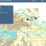
The city of Lawrence unleashed a beta version of an interactive map loaded with information in the city’s geographic information system, or GIS. The goal: Take the same facts used for everyday decisionmaking and information at City Hall, and get it into the hands — and through Internet browsers — of the public.
Some of the same detailed information that municipal engineers, administrators and other decisionmakers use to schedule sewer repairs, plan pavement upgrades and determine development patterns now is available for all to see.
One computer click at a time.
On Wednesday, the city of Lawrence unleashed a beta version of an interactive map loaded with information in the city’s geographic information system, or GIS.
The goal: Take the same facts used for everyday decisionmaking and information at City Hall, and get it into the hands — and through Internet browsers — of the public.
“If you need to get driving (or) transit directions, or the location of a particular business, stick with Google or Bing maps,” said Micah Seybold, the city’s GIS coordinator, in a blog posted at the city’s website, LawrenceKS.org. “The city map is going to have city of Lawrence information too detailed and specific for the big commercial maps.
“You can find out how your house is zoned, the quality of your street and when it was rated, the locations of underground pipes and depth of manholes, if your house is in a flood zone, where the nearest bike route is and other property information that commercial maps won’t have.”
The interactive map admittedly is a work in progress. Seybold has set up a page on the site for providing feedback, such as suggestions for additional features. Plans call for adding more data in the future.
Seybold’s advice for first-time users: Start by watching the instructional video at the site, which includes his own descriptions for how the map works and what it features it offers.
Adds Chuck Soules, the city’s director of public works, who regularly checks various locations’ pavement-condition ratings (zero being the worst and 100 being the best), storm sewer alignments and drainage contours: “It’s more information for people to use, however it best fits their needs.”
City Government

A STAR Bond application raises questions for city leaders about Costco and housing west of the SLT

Soccer gear honoring Lawrence history’s all-star team is now on sale as part of city’s public art exhibition

To honor public servants, Lawrence’s July 4 celebration will have a whole gallery of their photos on display; submissions open now

North Lawrence study consultants look at possibilities for a grocery store, food truck park, traffic calming and more

Algerian ambassador gives Lawrence a gift for supporting national team – a piece of art