Flood map delays spur angst – for no reason
Washington ? Delays in releasing new federal maps of New Orleans’ most flood-prone neighborhoods have slowed rebuilding, frustrated homeowners and created uncertainty about the future of the region ravaged by Hurricane Katrina.
And the angst may all be for nothing, the government says.
Residents of the city and surrounding communities have waited since the fall for the maps that will help determine how much flood insurance they will need to rebuild. Under current maps, 80 percent of New Orleans lies in a federally designated flood plain; that figure probably will rise.
Without the maps, homeowners say they do not know if they can afford to stay and buy the additional insurance required by mortgages or if they will be forced to leave and move farther inland.
The Federal Emergency Management Agency, which is issuing preliminary new building standards as early as this week, says homeowners do not have to make that decision now.
They say people who build now will not have to pay higher flood insurance rates even if the new maps and building standards eventually require higher rates. Only people building after the new maps and standards are finished will face higher rates, they say. That process could take another year.
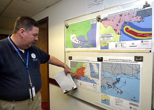
Butch Kinerney, of FEMA, shows a track map of Hurricane Rita on Sept. 21 in Washington, D.C. Delays in issuing maps of New Orleans' most flood-prone areas have sparked frustration.
The confusion is the latest example of Gulf Coast residents’ distrust of FEMA, which is widely blamed for the government’s slow and lackluster storm response. Katrina, which hit Aug. 29, left more than 1,300 people dead and hundreds of thousands homeless.
When asked why so many on the Gulf Coast believe the maps will have an immediate effect on insurance rates, FEMA flood map spokesman Butch Kinerney acknowledged, “They won’t believe us.”
He also said FEMA has not done a good enough job explaining its policy.
After months of delays, FEMA is expected to issue advisory standards this week suggesting how high homes need to be rebuilt to be considered safer from floods in Orleans, Jefferson, St. Bernard and Plaquemines parishes in southern Louisiana. Orleans includes the city of New Orleans.
The standards will be followed by geographic maps later this spring that probably will expand the boundary of the region’s flood plain – the area with the greatest potential to flood each year.
The flood plain maps have not been updated since the mid-1980s.
The preliminary building standards and maps must be approved by local officials, many of whom will spend the next year negotiating the details.
Construction begun before the maps are approved will be insured under current rates, FEMA’s Kinerney said. Only projects built after the maps are adopted will feel the rate change, he said.
National
Unhealthy air quality in California city as huge warehouse fire burns for 3rd day

Judge orders Trump administration to restore National Park changes at sites that ‘disparaged’ US
Teens’ reading and math scores have stagnated, US test results show
WASHINGTON (AP) — Younger students have regained ground academically after the pandemic's disruptions while older ...

Lawyers for man accused of killing Charlie Kirk try to block death penalty
Trump’s name poised to come off Kennedy Center