Lawrence could get around seven inches of snow during weekend storm; wind chills may hit 20 below zero
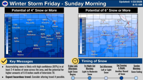
photo by: National Weather Service Topeka
Ahead of a winter storm that is expected to impact much of the eastern United States, the National Weather Service Topeka expects Lawrence could receive around seven inches of snowfall over the weekend.
Lawrence could get hit with around seven inches of snow over the weekend and face periodic wind chills of negative 20 degrees, according to the National Weather Service.
The weather impacts are due to a wide-ranging storm that will hit much of the eastern United States on Friday where forecasts anticipate around 150 million people will likely be hit by snow and ice, as the Journal-World reported.
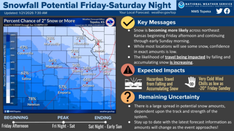
On Wednesday, the NWS Topeka office said Lawrence could see “several inches” of snow due to the storm, but the total snowfall was unclear because the main band of weather had not yet come ashore. Early Thursday morning, the NWS put much of northeast Kansas, including the city of Lawrence, under a Winter Storm Watch from Friday evening to Saturday evening. Heavy snow is possible, according to the alert, and total snow accumulations between 5 and 8 inches are possible.
Bill Gargin, a meteorologist with the NWS in Topeka, told the Journal-World Thursday morning that Lawrence and Douglas County are expected to get hit by two bands of snow that could bring as much as seven inches of snow to the area.
Gargin said that snow might move into Lawrence and other parts of northeast Kansas as early as late Friday afternoon, but it would be lighter snow. The snow is expected to pick up in intensity overnight Friday into early Saturday morning, Gargin said.
During the day on Saturday, there is expected to be a lull in the snow or light snow or flurries, but an additional band of weather could bring in several more inches of snow late Saturday night into Sunday morning. Gargin said the biggest factor in adding more snowfall would be based on how that second band moves.
“That’s what we’re watching,” Gargin said.
Along with the expected snow, the region will see “bitterly cold wind chills,” Gargin said. Lawrence, along with much of the region, is under a Cold Weather Advisory from Friday night until Sunday night, and that advisory could also extend until Monday morning, according to Gargin.
Temperatures will start to cool in Lawrence Thursday night, with a wind chills expected to be as low as negative 7 degrees after midnight. Gargin said that wind chills in the area from Friday to Sunday are expected to be around negative 15 to 20 degrees.
Monday temperatures are expected to warm up slightly to a high of 20 degrees during the day, but the wind chills could still be in the negatives Monday morning.
With the negative wind chills, the National Weather Service is advising people to stay indoors as much as possible, wear several layers of clothing including a hat, gloves and scarf and limit the time pets stay outside.
Public Safety
Lawrence could get around seven inches of snow during weekend storm; wind chills may hit 20 below zero
Frigid weather that ‘doesn’t let up’ expected over weekend with a chance of snow accumulation

Man crashes into five parked vehicles after attempting to avoid traffic stop

Rerouted drivers experience delays on Sixth Street after car hits telephone pole

Woman suffers critical injuries after two-vehicle crash just north of Lawrence
