Lawrence Loop feedback is in: People prefer a downtown trail route near the river and away from traffic
City plans to apply for state grant funding
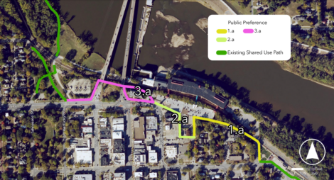
photo by: Screenshot/City of Lawrence
This image shows a preferred route for the downtown segment of the Lawrence Loop trail system based on public feedback.
Users of the Lawrence Loop trail system want it to stay close to the river and away from busy streets when its missing downtown segment is eventually built.
That’s according to the results of a survey and open house the city recently held to see which paths people wanted for the yet-to-be-completed sections of the Loop. The network of trails encircling the city has only a few holes left to close, and the city plans to apply for some state funding soon to build the downtown segment in particular.
The survey, which ran from Jan. 20 to Feb. 3, and the open house on Feb. 2 asked about three gaps: one in the downtown area, from the Amtrak station to Constant Park; one in the Pinkney neighborhood, from near Sandra Shaw Park to North Michigan Street across the street from the Pallet village; and one in northwest Lawrence, from Peterson Road to East 1000 Road.
In downtown, respondents were strongly in favor of staying away from busier streets like New Hampshire, Seventh and Kentucky. An option that would run along New Hampshire was the least popular segment, with only 21 people voicing support for it. Many respondents said inattentive drivers were too dangerous and that they wanted a completely separate path for bikes wherever possible.
“Real talk, drivers in Lawrence do not respect pedestrians or bicyclists. This is especially true around downtown Lawrence and 6th Street,” one respondent wrote.
The most popular segment, with 266 positive responses, would run past City Hall, and city spokesman Michael Leos said it was intended to pass underneath the Kansas River bridge. It and the other popular options form a path that hardly touches downtown, instead hugging the river and the railroad tracks most of the way. Some respondents said the route would be scenic as well as safe.
“It’s great to maximize likely glimpses of the river,” one wrote.
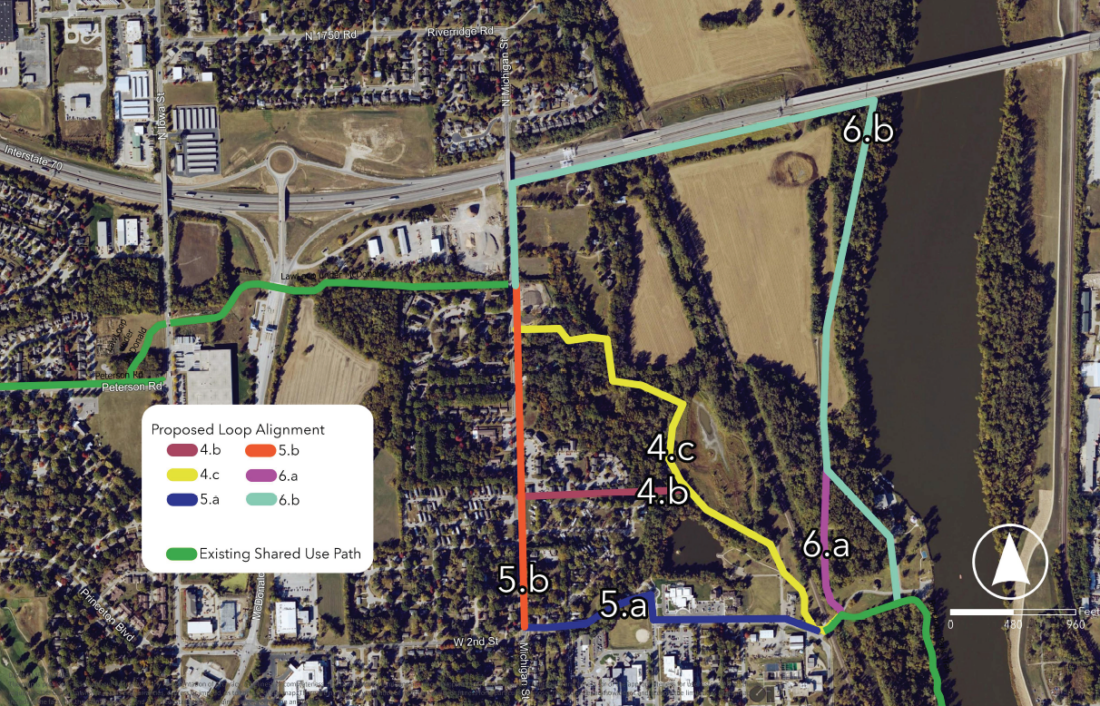
photo by: Screenshot/City of Lawrence
This map shows proposed Lawrence Loop trail routes in the Pinkney neighborhood. The yellow segment is the most popular one, according to the city’s feedback efforts.
Similarly, in the Pinkney neighborhood, not many respondents liked the options that went along existing streets. One option that would use West Second Street, passing the Treatment and Recovery Center and Woody Park, got just 40 responses in its favor, and another one that would run straight up Michigan/North Michigan Street got 54 favorable responses.
The most popular route here by far was a path that would run northwest along the edge of the neighborhood. It got 225 positive responses. Some commenters said they liked the woods and other scenery there, and others said it would be best to have a route that’s farther away from the Lawrence Memorial Hospital campus.
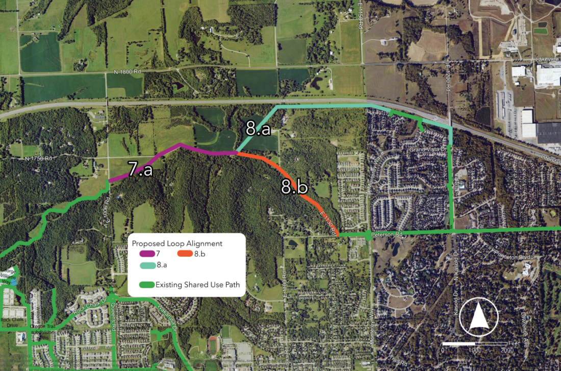
photo by: Screenshot/City of Lawrence
This map shows options for closing the northwest portion of the Lawrence Loop. The light blue option is the more popular one according to the city’s feedback efforts.
In west Lawrence, there were only two options and the survey was much closer: 198 people liked the first option that would follow Interstate 70 part of the way, and 145 people liked the second option that would run along East 1130 Road and Martin Park. Some commenters had concerns that the Martin Park option would be too steep.
“[G]oing down Martin Park Hill is not fun for your average rider,” one respondent wrote.
The city has been working on the more than 20-mile Loop for more than a decade now and has gotten help from grant funding along the way. It’s hoping to get a bit more from the Kansas Department of Transportation to help close the downtown section.
In a report to the Connected City Advisory Board, staff says the city intends to apply for funding from KDOT’s Transportation Alternatives Program, which funds pedestrian, bicycle and rails-to-trails projects throughout the state. The report said Transportation Alternatives grants typically reimburse 80% of the cost of a project.
Provided the city’s bikes plan steering committee recommends the proposed downtown route at its meeting on Feb. 25, the city will submit a concept for the downtown trail segment to the state. If that were approved by state officials, the city could apply for the grant later in the spring, and it would learn in the fall whether it had been selected to receive funding.
For many who gave the city feedback, any help in getting the Loop over the finish line would be welcome.
“Please close the loop as quickly as possible,” one wrote.
City Government
With new murals, Junior Girl Scouts and Jewish congregation hope to turn bland buildings ‘into something beautiful’

60 people from 23 states have applied for Lawrence’s city manager position, mayor says
City of Lawrence will soon start application process for a construction manager for Fire Station 6
Survey respondents think Lawrence is doing well on arts and culture, not so well on economy

Rising Rates: A three-part investigative series examines why Lawrence water and sewer bills have been soaring