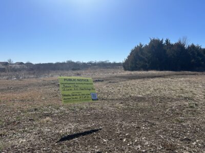
A proposed park north of I-70 would have trails that connect many dots on the Lawrence Loop and the Kansas River

photo by: Bremen Keasey
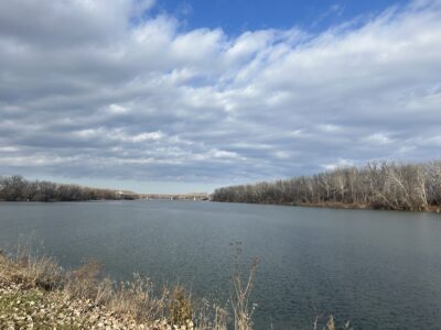
The view of the Kansas River from the Riverfront Park in North Lawrence, with Interstate 70 in the background. A proposal from a community group aims to create a park with trail system along the river called Cameron's Bluff Park.
Through her line of work, Sarah Hill-Nelson spends a lot of time thinking about the Kansas River and how to make it better.
Hill-Nelson is the current owner and operator of Bowersock Mills & Power Co.’s hydroelectric plant, which sits on the river right near Massachusetts Street. About 20 years ago, she was talking with someone with the electric utility now known as Evergy, which owns land along the river north of Interstate 70. They said the electric company can’t really do much with that land and would be willing to allow public use for a trail system along the river — if it could get built.
“I’ve been pecking away at this project ever since,” Hill-Nelson said.
Just like the river, that idea has had a winding course, but a plan to make it a reality is taking shape.
Through the discovery of an easement that makes it easier to access the trails, a feasibility report won through a grant and a lot of community organizations chipping in on funding, Hill-Nelson and Chris Tilden, chair of Friends of Lawrence Area Trails, will soon present the city with an idea for a trail system and park, which they are calling Cameron’s Bluff.
It’s still in the early stages, but Hill-Nelson is excited to see a real proposal that could better connect the river to the city.
“We can have a huge asset,” Hill-Nelson said.

photo by: Contributed
A concept map of potential trails for a proposed park north of Interstate 70 called Cameron’s Bluff Park.

photo by: Contributed
A map created by the International Mountain Bicycling Association which outlines the space north of Interstate 70 that a group of Lawrence residents are proposing can be turned into a park with a trail system called Cameron’s Bluff.
• • •
This progress would not have been possible without a feasibility study of the area led by the International Mountain Biking Association, Tilden said.
The IMBA is a “recognized authority on the development of trails,” Tilden said, and the group was out at the site, which hugs the Kansas River north of I-70, going up and then bending west, and is bordered by the BNSF railroad. That assessment, completed in 2024, included an ecological review to ensure potential development would be done in an “environmentally sustainable and appropriate way,” Tilden said.
The ability to get the IMBA to come out in the first place came thanks to a “trails accelerator grant” that Hill-Nelson applied for and received in 2022. The purpose of that grant was to help build trails in more developed areas — “right in people’s backyard,” as Hill-Nelson put it.
The IMBA deemed the space worthy of development and drafted some concepts for what the space could look like. Some of those concepts put forward by IMBA include trails accessible to regular traffic like walkers, hikers or bikers. Additionally, the park would feature a 3/4-mile track for mountain bikers.
Although the plan was put together by a group with an eye for biking or walking, Hill-Nelson said creating more access on the river would lead to other outdoor activities, too, including more fishing access.
“This space would be for all people,” Hill-Nelson said. “It’s for everyone.”
• • •
Although the IMBA report was useful, the proposal for the park might have still been up a creek without a paddle without the resurfacing of a recreational easement.
The report was positive, but there were still big questions about access. Tilden said the proposed park is pretty much cut off because of I-70 and there aren’t any connecting trails into the area, let alone many roads.
A possible access point might be from Burcham Park; however, several private properties sit between the proposed space and Burcham Park. In order to properly build through that, the city would either need to acquire those properties or gain an easement, Tilden said.
But the group recently discovered there was a recreational easement along the river from Burcham Park to the proposed site of Cameron’s Bluff, which would allow for the construction of those trails. Hill-Nelson said it was in place since the 1980s but “fell off people’s radar screens” in the intervening years.
It’s now one of the best options to create access to the area, Tilden said, and it can potentially be a connection to an even larger network.
Hill-Nelson said that the easement means the land could serve as an alternative option to close the Lawrence Loop trail system that encircles the city. She said the current plan to close the Loop in that area — a section from Michigan Street to Sandra Shaw Park that received a grant back in 2021 — would possibly go through private property, making it harder to complete.
Hill-Nelson said that since the Kansas Turnpike Authority has given permission to potentially use its right-of-way for a path as part of the Loop, adding the proposed path along the river could help close the Loop and give users of the trail system direct access to the river.
“It’s a potential double win,” Hill-Nelson said.
Even if it does not become a part of the Lawrence Loop itself, it’s in a key location right by the Pinkney neighborhood, Bert Nash Community Mental Health Center and the hospital, Hill-Nelson said. Tilden added that if it can connect through Burcham Park, it provides more connectivity to the heart of Lawrence.
“It could be a great way for people from downtown to hop on the Burcham Park trail and readily access that area in a simple manner,” Tilden said.
• • •
The name of the proposed park honors a unique historical figure in Lawrence: Hugh Cameron, who was known as the “Kansas Hermit.” He was an abolitionist who moved to Lawrence in the 1850s, served as a Union soldier and became known as a local character — growing his hair and beard for years and living in treehouses across the city, including one near the proposed park.
Tilden said he feels the name is a great homage to “celebrate a really unique aspect of Lawrence history,” and if the project continues to develop, he hopes to add some historical signage to teach people about Cameron.
That is one of the many details to be ironed out. As the ideas for the park take shape, a “laundry list” of partners have been weighing in, Tilden said.
Initially, the Lawrence Mountain Biking Club was taking a lot of the lead in developing the idea, but once a proposal for the city was being formulated, Tilden said his group was asked to take the lead in communication and coordination.
Tilden said that FLAT chipped in for the match funding as part of the grant for the trails report, and Hill-Nelson said it’s been crucial to have a lot of big partners involved. The fact Evergy was willing to open up its land for the community is a “huge gift” in a state that has little public land available for recreation. Data from the U.S. Geological Survey shows that 98.3% of land in Kansas is privately owned, and that includes 91.3% of land in Douglas County.
Outside the land use, Hill-Nelson said Evergy had promised to contribute some labor and other help for building the trails. Bowersock Mills & Power Co. also has committed to “spearhead the maintenance” of any trails that get developed for Cameron’s Bluff, she said.
Estimates for the development of the trails put forward in the IMBA report suggest the cost to build the trails themselves would range from about $118,000 to $317,000 — with costs even lower if Evergy follows through in helping to build some of the trails.
That’s crucial because the city and the Parks, Recreation and Culture department are facing a budget crunch. Tilden said it’s been crucial for the group to be able to leverage private funds to explore the feasibility and potentially pave the way for the project.
The first public meeting on the idea will be the Parks and Recreation Advisory Board’s meeting on Monday night. That will take place at 5:30 p.m. at City Hall, 6 E. Sixth St. Hill-Nelson hopes the proposal will get some initial support, which could lead to more public feedback efforts about the project.
Tilden said the proposal is exciting for a variety of reasons, but it’s especially great since it flows well with many of the city’s strategic goals. Activating the riverfront — goals of the downtown and city’s master plan? Check. Managing a large trail system — part of the PRC’s master plan? Check. Possibly completing the Lawrence Loop? Check.
Adding another space along the river adds to the diversity of trails the city offers as well, Tilden said — complementing other scenic trails like the ones that connect with the Baker Wetlands — and can make Lawrence stand out even more.
“It would really put a stamp on Lawrence for recreational trails in the Midwest,” Tilden said.
City Government
Connecticut Street sidewalk project is producing a mix of concrete and brick — and a mix of emotions

City staff says it would cost $18,000 a year to open Community Building for youth part-time; leaders to receive report on it next week
Affordable Housing Advisory Board recommends funding for Floret Hill, tiny homes, vouchers and more
Lawrence City Commission approves ‘modest’ increase in some traffic fines for 2026
City to host event for residents to share ideas on the future of North Lawrence