Surveyor’s ‘holy grail’ is little rock up north
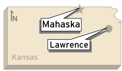
In the middle of nowhere, precisely one mile north and west of a town called Mahaska, sits a rock.
If it weren’t for a strange monolith sitting atop this rock, no one would notice it. But that doesn’t mean it’s not important.
Nearly 150 years ago, Surveyor General John Calhoun chose that spot as the initial point of the Sixth Principal Meridian. The 6th P.M., as surveyors call it, is an imaginary line that extends north and south through Nebraska and Kansas. Its initial point, which is marked by the rock and monolith, is where surveyors started when they divided Kansas into 6-mile squares called townships.
Think of it as the Kansas surveyor’s holy grail.
Steve Brosemer, a professional land surveyor in Emporia and 6th P.M. history buff, said every land measurement in the tristate area goes back to that rock.
“The importance to the average citizen is that every single legal description of every piece of property … all starts from that point,” Brosemer said.
Lawrence, for example, is 17 townships east and 12 townships south of the initial point of the 6th P.M. Every land title in town contains some reference to the 6th P.M.
John Selk, a principal surveyor at Landplan Engineering in Lawrence, said that although the 6th P.M. is historically important, surveyors today don’t use it every day.
“Probably very few know anything about it,” Selk said.
“Most surveyors work in a relatively small area, and we’re quite a ways east, obviously, of that 6th Principal Meridian.”
Douglas County surveyor Michael Kelly said that though surveyors don’t reference it every day, the 6th P.M. is the backbone of Kansas’ surveying grid.
Kelly often uses the analogy of a quilt to explain the 6th P.M.’s importance. Imagine that Kansas, Nebraska, Colorado and most of Wyoming are covered in a giant quilt. The 6th P.M. would be the major line running north and south on the quilt, and its initial point would be a nail holding the quilt in place. Without it, surveyors wouldn’t have an initial reference point.
“Now it’s kind of like the quilt has already been made,” Kelly said.
So why did Calhoun choose that point? It had to be somewhere, Brosemer said. He added that Calhoun chose a point on the Kansas-Nebraska border exactly 108 miles west of the Missouri River.
“They thought most of the land west of 108 miles would never have anybody on it but Indians … and hoot owls, long-eared rabbits,” Brosemer said.
“This is going to be bad news to Dodge City and Great Bend.”
The spring of 1856 is famous for more than just the 6th P.M. – Quantrill’s raid, John Brown and the Battle of Wakarusa are all contemporary to that event, Brosemer said.
He added that surveyors during that time were “interwoven in the fabric” of politics. Most were pro-slavery and anti-free state.
The reason surveyors needed to pinpoint the 6th P.M. was so the government could divide up the land and give it to veterans of the Mexican-American War.
“They were doing it all on paper back in Washington,” Kelly said.
“They were drawing this all out. They said, ‘We have this many acres of ground out there and we have to tell people where it is.”
Because Kansas and Nebraska were fairly uncharted territories in those days, dividing it up was hard work. Surveyors used a series of poles, chains and sun dials to ensure accuracy.
All of them started at the Initial Point of the 6th P.M., a point that, as Brosemer said, “is just a rock.”
Marking a milestone
What: The 150th anniversary of the Monumentation of the Sixth Principal Meridian.
Where: Exactly one mile west and one mile north of Mahaska
When: 9 a.m. Saturday
How much: Free
Activities: Surveyor chaining e-enactment at the initial point of the 6th P.M., 9 a.m.; display of antique equipment by Kansas Society of Land Surveyors and period re-enactment, 10 a.m.; lunch, 11:30 a.m.; program on history of 6th P.M., 12:30 p.m.
City Government

Developer seeks incentive from City of Lawrence to build 131 units of housing near Wakarusa and Queens

Lawrence city leaders will consider whether to keep Community Building open, make 2 other rec centers free to access

A STAR Bond application raises questions for city leaders about Costco and housing west of the SLT

Soccer gear honoring Lawrence history’s all-star team is now on sale as part of city’s public art exhibition

To honor public servants, Lawrence’s July 4 celebration will have a whole gallery of their photos on display; submissions open now
