
Scorching Temperatures Are Back Again
I suppose that it is bound to happen. It is August in Kansas after all. Extreme heat will make its return to northeast Kansas by Sunday and keep going well into next week.
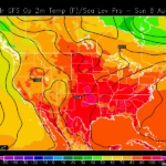
Computer models are consistently putting our daytime highs into the mid-to-upper 90’s through Thursday of next week, and even after that it looks like most models are only bringing a slight change to the daytime heat.
Sunday’s Daytime Highs From GFS Computer Model
During this stretch we hold only minimal chance for rain with only the blazing sun to deal with. So far in August we have managed to somehow avoid any measurable precipitation. We typically average 0.11″ of precipitation a day. Obviously that is an average, but six days into the month we are already 0.66″ down in what is typically our driest summer month.
I took some time to look back at the official numbers for July and found something that stood out to me. It took 12 days into July before we saw our first 90° day. After the 12th we had only one day that was in the 80’s.
If you work outside for a living, or just plan on spending some time outdoors, remember to drink plenty of water, wear light-colored clothing, and take frequent breaks. It is also a good idea to check on elderly family or neighbors from time to time, especially if they don’t have air conditioning or it isn’t efficient.