National Weather Service backs off snow totals for Lawrence, but warns of dangerous wind chills
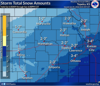
photo by: National Weather Service
While this weekend’s winter storm already has delivered on the predicted bitter cold, it is likely to produce snowfall amounts slightly less than originally forecasted, the National Weather Service office in Topeka said.
Exact snow fall totals in Lawrence weren’t immediately available, but the National Weather Service estimated 1 to 2 inches of snow had fallen by midnight in the Lawrence region, and less than an inch more had been added by 6 a.m..
For the rest of Saturday, the heaviest snowfall is expected to occur before noon, with 1 to 2 inches of snow likely before the lunch hour. Additional snow Saturday afternoon and through Saturday night is expected to be less than an inch. Currently, forecasters are not predicting any snow for early Sunday morning in Lawrence.
In total, the National Weather Service is expecting the storm to produce 2 to 3 inches of snow in the Lawrence area.
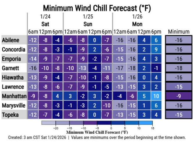
The area still remains in a winter storm warning, and travel is highly discouraged. Dangerous wind chills continue to be forecasted for the area, and the latest predictions call for the coldest of them to extend into early Monday morning. The National Weather Service is forecasting wind chills of negative 15 degrees at 6 a.m on Monday.
Today, wind chills are expected to range from negative 13 this morning to negative 6 at 6 p.m. this evening. On Sunday, wind chills are forecasted between negative 9 degrees and negative 1 degrees.
Other News
National Weather Service backs off snow totals for Lawrence, but warns of dangerous wind chills

For Theatre Lawrence’s ‘The Mountaintop,’ actor had to find a vulnerable, human way to play MLK

Weather-related closings, cancellations and delays for Jan. 24

Lawrence school board members to consider plans for ‘nontraditional’ high school at former Centennial Elementary building

U.S. on the verge of losing its status as measles-free nation; a look at what Douglas County has seen