Storms, flash flooding inundate Lawrence area; more expected as Weather Service warns of danger

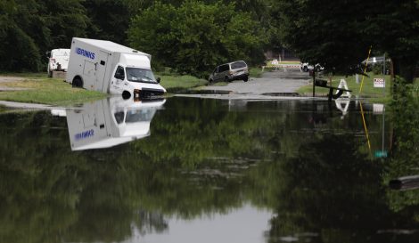
photo by: Mike Yoder
An armored truck is caught in flood waters near North Fifth and Maple streets in North Lawrence, Thursday, Aug. 1, 2019.
Updated at 6:25 p.m. Thursday
Lawrence and Ottawa were in the bullseye of heavy thunderstorms, bringing around 8 inches of rain to the area southwest of Lawrence through Thursday morning and necessitating multiple water rescues.
Lawrence-Douglas County Fire Medical was called to rescue nine people from homes around the Lone Star Lake area between 7:20 and 11 a.m. Thursday, and it had to rescue three individuals from flooding along Washington Creek, one of those in a vehicle, according to Karrey Britt, spokeswoman for Douglas County.
A number of roads were flooded throughout the county, including the underpass leading into North Lawrence from downtown Lawrence, necessitating detours.
The rain, which began Wednesday evening, continued through late Thursday morning and was expected to return Thursday evening.
“Emergency Management is closely monitoring the weather forecast through Saturday because there are several chances for heavy rainfall,” Britt said. ” We strongly encourage residents to sign up for the Northeast Regional Notification System, which can be found on the Douglas County website.
Rainfall in the area varied greatly. While areas southwest of Lawrence saw 8 inches, the total rainfall at the Lawrence Municipal Airport from the storm was 3.67 inches, according to Jenifer Prieto, with the National Weather Service in Topeka.
The Douglas County Sheriff’s Office warned people Thursday morning to turn around and not cross inundated roads, said Jenn Hethcoat, the office’s public information officer. By Thursday afternoon, in anticipation of more rain, the city of Lawrence also issued a reminder for residents that crews work quickly to barricade streets and create detours; for safety, no one should drive around flood barricades or drive through high water.
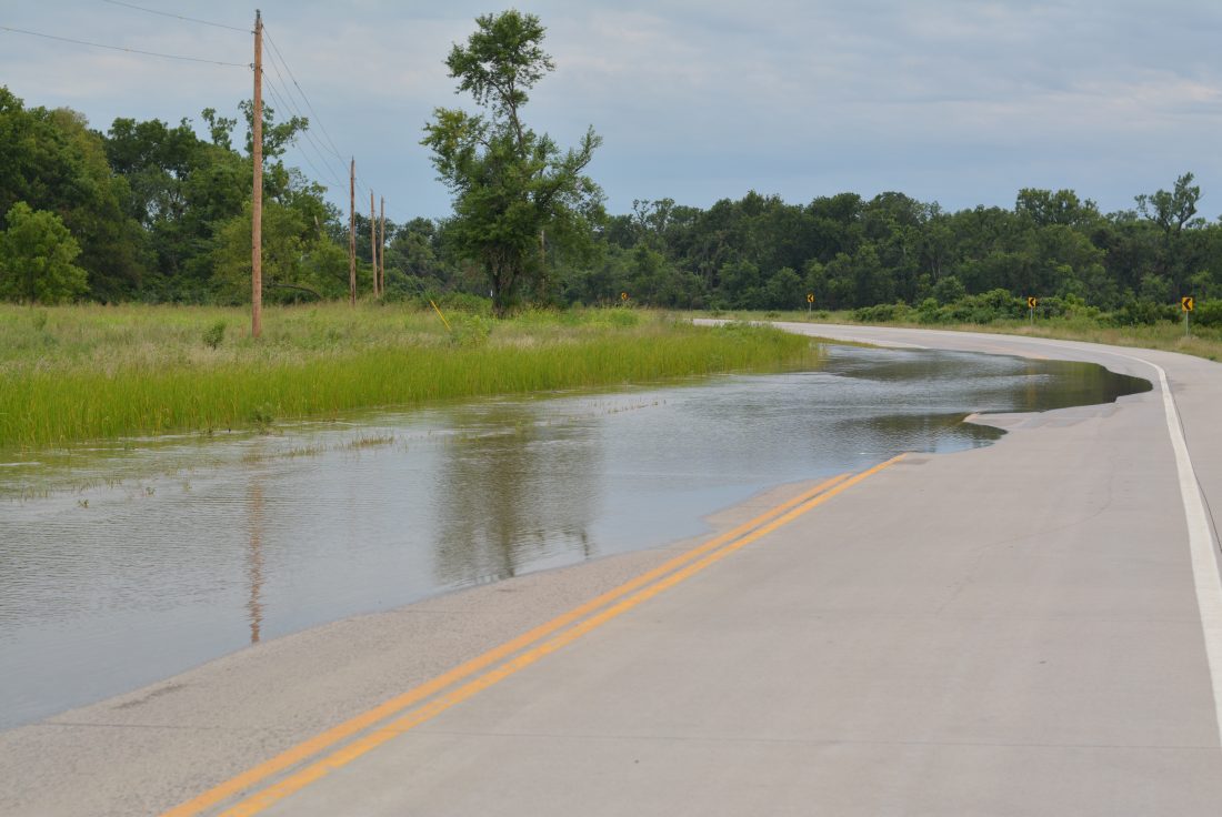
Part of County Route 1055 near the Baker Wetlands had been damaged in the storm, a Journal-World reporter on the scene observed. The road was reduced to one lane between 31st Street and the Wakarusa River bridge.

photo by: Jackson Barton
Flood waters cover a section of County Route 1055 south of 31st Street on Thursday, Aug. 1, 2019.
In addition, houses in the Lone Star Lake area, about 8 miles southwest of Lawrence, experienced severe flooding, according to Chad Voigt, Douglas County’s deputy public works director.
Prieto said that more rain would exacerbate the flash flooding problem, and noted that flash flooding could occur anywhere, even in places that have never flooded before,.
“People need to keep a weather radio handy throughout the night and have an evacuation plan,” she said.
While a reprieve in the rain occurred Thursday afternoon, an 80% chance of rain remained Thursday night and into early Friday, said Kevin Skow, a meteorologist with the Weather Service.
“We are looking for 1 to 2 inches of rain falling — and locally heavier rainfall exceeding 6 inches in a very narrow band,” Skow said, noting that it would be hard to pinpoint exactly where the heavy rain would fall.
Thursday’s storms were concentrated in a 20- to 30-mile band. That could repeat itself in the same area during storms Thursday night and Friday, he said.
On Friday night there’s a 60% chance of showers and thunderstorms, with some of the storms producing heavy rain. A 30% chance of rain will continue into the morning Saturday.
“It should clear off and the heavy rainfall should be over by then,” Skow said.
Sunday is expected to be sunny with a high near 85. The week will see increases in temperatures into the 90s, with only a slight chance of rainfall through midweek.
According to Weather Service records from the Lawrence Municipal Airport, more rain fell on Thursday, the first day of August, than during the entire month of July. Total rainfall for July was 2.16 inches, compared with the 3.67 inches recorded before 11 a.m. on Thursday.
Year to date, 29.4 inches of rain have fallen in Lawrence, which is 5.88 inches above normal, Prieto said.
The Weather Service issued a flood warning for the Wakarusa River near Lawrence until Friday afternoon. Moderate flooding was expected as the river rises over its flood stage of 23 feet.
Rainfall at Clinton Lake Thursday morning measured 8.2 inches, according to R.J. Harms, U.S. Army Corps of Engineers project manager at Perry and Clinton lakes.
“The lake has come up a foot or so over the past 24 hours,” Harms said. “We had been releasing 3,000 cubic feet per second from the lake for a while, but with all the rain last night, at 8 this morning we shut off the release.”
With more rain in the forecast, he said the concern would be with the creeks around the area rather than with Clinton Lake.

photo by: Mike Yoder
Flood waters cover a large part of East 1400 Road southwest of the Baker Wetlands Discovery Center, near the Wakarusa River, Thursday, Aug. 1, 2019.

photo by: Mike Yoder
Flood waters cover the bike and pedestrian path that runs under the South Lawrence Trafficway near 31st and Louisiana streets, Thursday, Aug. 1, 2019.

photo by: Mike Yoder
Motorists drive through flood waters along U.S. Highway 24-40 near the Lawrence Municipal Airport, Thursday, Aug. 1, 2019.

photo by: Mike Yoder
The underpass along North Second Street by the Union Pacific Depot in North Lawrence closed because of flooding on Thursday, Aug. 1, 2019.

photo by: Mike Yoder
Flood waters fill Naismith Valley Park at 27th Street in southern Lawrence, Thursday, Aug. 1, 2019.

photo by: Associated Press
A Wakarusa Township firefighter talks with motorists at a road closing near Lone Star, Kan., Thursday, Aug. 1, 2019. (AP Photo/Orlin Wagner)

photo by: Associated Press
Flood water flows past a road sign near Lone Star, Kan., Thursday, Aug. 1, 2019. Heavy rain overnight caused flash flooding in the area. (AP Photo/Orlin Wagner)

photo by: Associated Press
A local resident takes pictures of flash flooding along Washington Creek near Lone Star, Kan., Thursday, Aug. 1, 2019. (AP Photo/Orlin Wagner)

photo by: Associated Press
A Douglas County public works employee waits for flood water to recede at a road closing near Lawrence, Kan., Thursday, Aug. 1, 2019. (AP Photo/Orlin Wagner)

photo by: Douglas County Public Works
Flooding is pictured at Route 1 into Lone Star, Thursday, Aug. 1, 2019.

photo by: Douglas County Public Works
Flooding is pictured along Route 458 at the intersection of North 1000 and East 1000 roads, southeast of Clinton Lake, Thursday, Aug. 1, 2019.

photo by: Douglas County Public Works
Flooding is pictured along Route 1045, also known as old Highway 59, in southern Douglas County, Thursday, Aug. 1, 2019.

photo by: Douglas County Public Works
Flooding is pictured along Route 1045, also known as old Highway 59, in southern Douglas County, Thursday, Aug. 1, 2019.

photo by: Douglas County Public Works
Flooding is pictured along Route 1045, also known as old Highway 59, in southern Douglas County, Thursday, Aug. 1, 2019.

photo by: Douglas County Public Works
Flood waters force the closure of Route 458 west of U.S. Highway 59 after heavy overnight and morning rainfall, Thursday, Aug. 1, 2019.


