After marathon meeting, Planning Commission recommends approval of New Boston Crossing developers’ changes to land use map
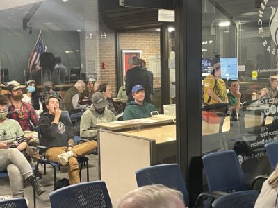
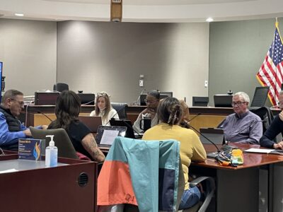
photo by: Sylas May/Journal-World
An overflow crowd sits in City Hall's lobby during the Planning Commission's meeting on Wednesday, Oct. 22, 2025.
In a marathon meeting that included more than an hour of public comments, planning commissioners on Wednesday took a step requested by the developers of the New Boston Crossing project — but made it clear that there’s still much to be figured out about the proposed development south of the South Lawrence Trafficway.
The developers requested a change to a land use map in the city-county comprehensive plan, Plan 2040, to include more area for commercial and high-density residential uses at the proposed New Boston Crossing site, at the southeast corner of U.S. Highway 59 and the SLT. And on Wednesday, the Planning Commission voted 5-3, with Commission Chair Chelsi Hayden, Vice Chair Jane Eldredge and Commissioner Charlie Thomas opposed, to send that change to the city and county commissions with a recommendation for approval.
“This is not step 1, but it’s step 1A,” Planning Commissioner Mike Kelso said.
New Boston Crossing recently took a turn in its design, as the Journal-World reported. The project had previously won approvals for a development that included single-family and duplex housing, but the plans now call for less housing and some new sports fields such as a lacrosse stadium.
In a letter to city officials recently, Landplan Engineering’s Corby Rust, a representative of the development group, had acknowledged that the residential parts of the approved plan had been met with some opposition, “particularly the residential areas being so close to the Wakarusa River and its floodway.”
That opposition was on display on Wednesday night, in the form of an overflow crowd of public commenters. But the planning commissioners had questions not about the project itself, but about the process — how changes to the top-level land-use plans are made, and how involved the community should be in those decisions.
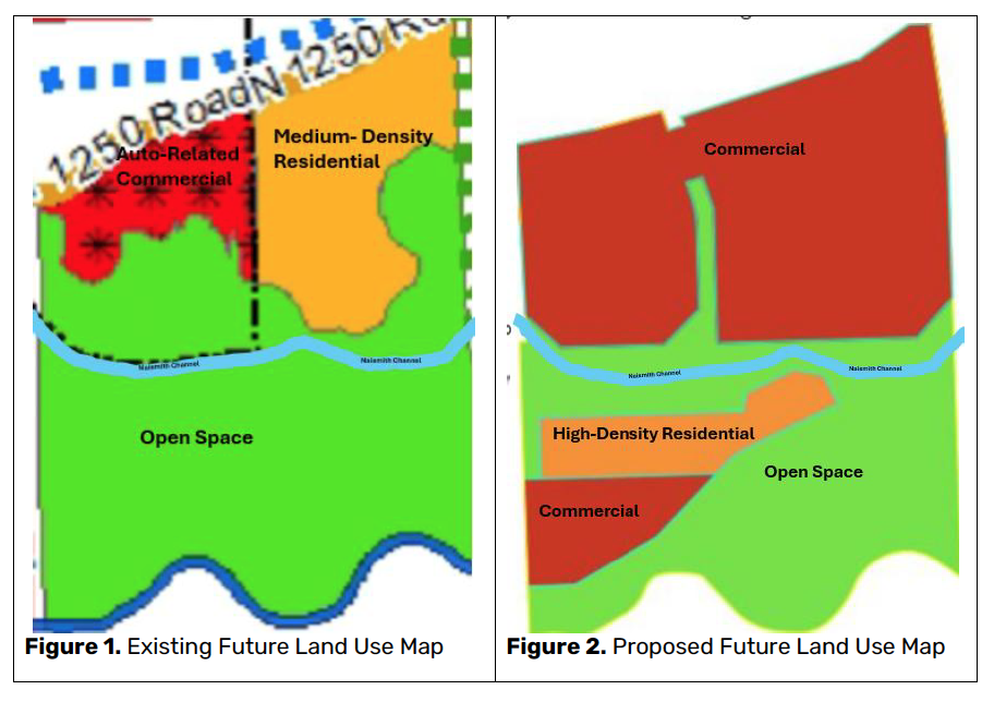
photo by: City of Lawrence
These images from planning staff show the existing land use map for the New Boston Crossing site, left, and the proposed changes from the New Boston Crossing developers, right.
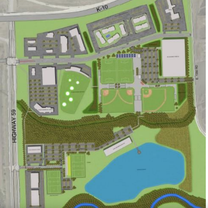
photo by: City of Lawrence
A concept plan for a mixed-use development at the southeast corner of U.S. Highway 59 and the SLT is shown.
• • •
Rust and another Landplan representative, Chandler Foresman, did share with the commission some features of the new concept on Wednesday, including a “bioswale” channel with stone dams and native plants that would manage runoff and a “barefoot park” where people could directly access the Wakarusa River.
But what the Planning Commission had to decide on Wednesday night was not related to the specifics of what Landplan was proposing.
Instead, it had to make a recommendation to the city and county commissions about whether to change an abstract, broad-strokes land use map that hasn’t been updated since before the South Lawrence Trafficway was constructed.
This map is called the Revised Southern Development Plan, and it’s part of the city-county comprehensive plan called Plan 2040. Planner Sandra Day gave the commission a brief overview of this map’s history and what it’s for.
The map began its life as the Southern Development Plan, which was adopted in 1994 to guide Lawrence’s growth in that direction. Back then, the area that New Boston Crossing is eyeing today was labeled as land that could be used for office or industrial space far in the future.
Then, in 2007, the Southern Development Plan was revised. In this new version, some areas just south of the SLT — which, in 2007, was merely a dotted line labeled “future freeway” — were changed to auto-related commercial development or medium-density residential areas. Most of the land where New Boston Crossing is now hoping to locate was still labeled as open space, however.
Since then, Day said the Revised Southern Development Plan hasn’t changed much. The last time it was amended was in 2013, during the development of the Menards store on 31st Street, which was still before the opening of the SLT.
Day emphasized that the changes that New Boston Crossing’s developers were seeking would be to a very “high-level” plan — one that doesn’t show every detail of proposed developments. As an example, she used that Menards store: The top-level map showed the Menards site as a mix of commercial and open space, and its zoning was commercial, but the more specific plans for the project still included a green space easement for a path that connected to Naismith Park.
She said that there would be opportunities to fine-tune things in the future.
“They get through this process, one way or the other, they’re going to have to go through a zoning process,” Day said. “That will be a public process,” and there will be other steps involving the plat for the property, too.
“Again, we’re asking you to look at the big picture. Is this category appropriate or not appropriate?”
• • •
The commission had a lot to say not just about whether the category was appropriate, but also about whether the process for changing the map was appropriate.
Specifically, some commissioners said they had concerns about updating a map that hadn’t been changed in many years based on just a request from one developer.
Day said it was “not unusual” for the Planning Commission to consider changing parts of Plan 2040 in response to a developer’s request.
“We see applicant-driven projects all the time,” Day said.
But Thomas likened the process of amending the maps based on requests from developers to playing “Whac-A-Mole.”
“Somebody comes in and wants something, so we’re going to shift everything around.” he said. “… So I’m a developer, I come in, I want this, ‘whack.’ I’m another developer, I want something different, ‘whack.’
“… I’m not sure that’s what the comprehensive plan is asking us to do,” he added.
He said he’d rather see a process where the community decides that “this is really what people are looking for and would like,” and then it would be up to developers to create projects that fit those standards.
Such a community discussion hadn’t happened in a long time, Hayden said.
“Over 18 years ago was the last time that the community had an opportunity to really do a robust review of, ‘what does this sector of land mean to us as a community?'” she said. Later, she said that much of the “us vs. them” mentality around projects like this was caused by changes to the plans “coming through this way,” rather than through a community conversation.
But Commissioner Gary Rexroad said that the commission also had a process for considering requests from developers, and that it should follow that process on Wednesday night.
“We don’t have a process like you’ve described,” he said. “… But we also as a community have this mechanism for someone who wants to do something … and they bring that to the city.
“And the city works with them over months, at great expense, to get to a point where we are tonight, where the criteria is understood and given to us to make a decision.”
• • •
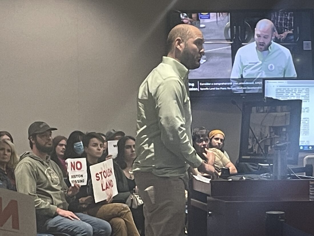
photo by: Sylas May/Journal-World
Zack Pistora, of the Kansas Sierra Club, speaks during the Planning Commission’s meeting on Wednesday, Oct. 22, 2025.
The crowd, which spilled out of the commission chamber into the overflow seats in City Hall’s lobby, spent more than an hour voicing its frustration with New Boston Crossing and urging commissioners not to recommend the request for approval. People carried signs like “NO BOSTON CROSSING,” “STOLEN LAND” and “WATER IS LIFE,” and many of them spoke emotionally to commissioners about their personal connections to the nearby Baker Wetlands.
Zack Pistora, of the Kansas chapter of the Sierra Club, said that the area proposed for New Boston Crossing “should look a lot, inevitably, like the Baker Wetlands instead of what’s across the road.” He characterized the developers’ environmental proposals as “lipstick on a pig — and that’s coming from a kid who grew up on a pig farm.”
And Kelly Barth, of the Lawrence Bird Alliance, said she was concerned about the impact of lighted sports fields on migratory birds’ ability to navigate at night. “They’re our neighbors,” she said, and noted that populations of many birds were dwindling in Kansas, including the state bird, the meadowlark.
Many were concerned about flooding, including Earl Bates, of Save the Wakarusa River Valley, who said he lived “a stone’s throw” from the proposed development site. He recalled a story of one resident who “had a neighbor of his jet-ski across the water on his bean field during the 2019 flood.”
“This is a bad idea,” Bates said of the development. “It’s in a floodplain! It’s gonna flood. Eventually it will flood, and who’s gonna pay for that? We all are.”
Multiple commissioners acknowledged the crowd’s frustrations.
“I look at the map, and I hear the commentary about Baker Wetlands and how vitally important it is, and I agree,” Rexroad said. He later added, “I struggle with the idea it has to be just one thing or the other, that we can’t find ways … to coexist.”
And Kelso said there were many competing interests that needed to be balanced: “Do we want to ruin the wetlands? Absolutely not. Do we want to protect them? Absolutely. Do we want to use what is potentially … a very, very valuable potential piece of commercial property for the county, for Lawrence, in bringing in tax dollars?”
That balancing act, Kelso said, will take much more than one long and at times emotional meeting.
“This is simply one step” in the process, he said, in the “dozens of steps of whatever this ends up being on this property. Tonight’s just one part of that.”
City Government
City Commission approves $3.15M funding agreement with Lawrence Community Shelter
More than 2,250 people now have memberships to Lawrence rec centers — over 75% of Parks and Rec’s goal
After public feedback sessions, South Park is standing out to the Lawrence Farmers Market as a potential permanent home
99-year requirements, revolving loans and other puzzle pieces of Lawrence’s proposed housing incentives policy
City Commission to consider $3.15M funding agreement with Lawrence Community Shelter for 2026