Concept plan for East 23rd Street includes safety, pedestrian and aesthetic improvements

photo by: Olsson
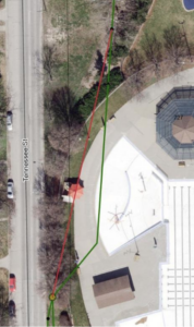
A draft concept plan for the redesign of East 23rd Street shows recommendations for one section of the roadway.
A draft concept plan for a redesign of East 23rd Street includes narrower driving lanes with lower speed limits, 10-foot-wide pedestrian paths with lighting, as well as additions such as native plants and monuments to beautify the corridor.
The Lawrence-Douglas County Metropolitan Planning Organization has been working with a consultant to conduct a study and create a new transportation plan for East 23rd Street now that it is no longer a state highway. The plan will inform the upcoming redesign and reconstruction of the street from the Haskell bridge to the eastern city limits.
Transportation Planning Manager Jessica Mortinger said the East 23rd Street Multimodal Corridor Plan aims to address the needs of all those who use the street — including commuters, businesses and residents of adjoining neighborhoods — as well as improve the aesthetics of the corridor.
“It’s an arterial street, so it’s also used by people trying to get in and out of your community,” Mortinger said. “How do you visually make that appealing, but also make it function for all the people who might need to use it and ensure you have a place that people want to be?”
The plan says many of its recommendations are aimed at improving safety on the corridor. The accident rates along this corridor are above those in similar corridors due to several contributing factors, the plan says: frequent driveways, wide lanes that contribute to high speeds, and the transition from high speeds on Kansas Highway 10 to the lower-speed traffic on a city street. The speed limit on 23rd Street is 35 mph west of Learnard Avenue, and the speed reductions would bring an adjoining section of the road in line with that speed limit.
Some of the major traffic, bicycle, pedestrian, public transit and aesthetic changes to the roadway are summarized below. The full plan is available on the city’s website.
• Traffic and safety changes: Recommendations in the plan include adding raised medians for intersections with traffic lights to better guide drivers; reducing the speed limit from 45 mph to 35 mph west of Harper Street; and narrowing traffic lanes on the western portion of the corridor to help reduce speed. The plan also recommends closing some driveways as properties are developed or redeveloped to reduce conflict points, improve traffic flow and enhance safety.
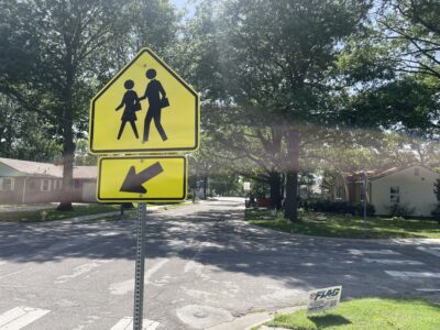
• Bicycle and pedestrian changes: Multi-use paths wide enough to accommodate pedestrians and bicycles are recommended for both sides of 23rd Street. An 8-foot-wide path is proposed from Learnard Avenue to Harper Street and a 10-foot-wide path is proposed from Harper Street to the eastern city limits. The paths tie into the proposed future bikeways in the Lawrence Bikes Plan.
• Public transit changes: The plan notes there is only one transit shelter on East 23rd Street and recommends that each bus stop along the roadway include clear signage, informational kiosks, a bench, protected shelter, and a concrete pad that connects the sidewalk to the bus to improve accessibility. The plan recommends that a transit stop be added on both the eastbound and westbound sides of 23rd Street at O’Connell Road to improve access to the nearby business parks and to ensure there are stops every half-mile along the most traveled sections. It is also recommended that the bus pullout on the east side of Harper Street be relocated upstream of the traffic signal to make it easier for buses to get back into traffic.
• Aesthetic changes: The plan recommends improving the aesthetics of the roadway, as it is one of the primary entry points into the city. The plan’s primary recommendation is to add low-maintenance, native plants — including perennial flowers, ornamental grasses and trees — to select medians and right-of-way areas. Other recommendations include a monument or other gateway feature that represents the city and marks the area as one of the “front doors” to the city; replacing cluttered, dated and inconsistent business signage with signage that is coordinated in design, size and character and integrated with the landscape; replacing dated lighting and adding pedestrian lighting for the multiuse paths; and burying utility lines or making them less conspicuous by shielding them with landscaping or using fencing to hide them.
The engineering and design firm Olsson, which the city hired to conduct the study and create the plan, will present its recommendations at three upcoming meetings before the plan goes to the City Commission for consideration sometime this fall. The plan will be presented to the MPO Technical Advisory Committee on Sept. 3, the Transportation Commission on Sept. 9, and the MPO Policy Board on Sept. 19.
The $100,000 study to develop the plan is funded by an $80,000 grant from the Kansas Department of Transportation and a $20,000 contribution from the city. The city has budgeted $9.75 million for the East 23rd Street reconstruction project in coming years, which includes $5.8 million of anticipated funding from KDOT. The design of the roadway will begin in 2020, and $500,000 for the project is included in the city’s capital improvement plan for next year. The project is scheduled to begin in 2021 and be completed the following year.
City Government
Lawrence’s acting city manager says roughly 2-mill increase in 2027 budget is a ‘last resort’; one commissioner wants to avoid it
Police department paid $1.7 million to county last year in jail costs; chief says that’s too much

Organizers to host public forum on how Lawrence can achieve renewable energy goals
When will Ninth Street reopen? When will Mass. Street construction begin? Here’s where road projects around Lawrence are at
As Lawrence and partners update school routes, they’ve seen less walking and biking to most schools