Lawrence City Commission approves 143-acre annexation for SLT and Iowa Street development

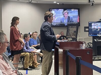
photo by: City of Lawrence screenshot
Phil Struble, of Landplan Engineering, speaks to the Lawrence City Commission during its meeting March 14, 2023, about the conceptual plans for the development. Those include a mix of housing types, including 46 acres of small residential lots and 18 acres of larger housing lots that would accommodate “mid-level” homes.
Story updated at 12:22 p.m. Wednesday, March 15:
Lawrence city leaders have voted to expand the city’s boundaries in the area of the South Lawrence Trafficway to allow for a development that plans to add dozens of acres of new homes as well as additional commercial space to the city. However, opponents continued to voice long-standing concerns about the proximity of the property to the Wakarusa River and wetlands.
As part of its meeting Tuesday, the Lawrence City Commission voted 3-2, with Mayor Lisa Larsen and Commissioner Courtney Shipley opposed, to approve an annexation request for 143.41 acres located in the southeast corner of the South Lawrence Trafficway and Iowa Street (U.S. 59).
Commissioners in favor of the annexation agreed that the city needs additional housing, and said that concerns related to the project, which center on its proximity to a floodway, would be looked at in detail as it progresses. Conceptual plans for the project call for a variety of lot sizes and housing types, including small-lot homes and townhomes, and Commissioner Amber Sellers said the annexation could be an example of how the city creates more housing at lower price points.
“If we want to be welcoming, safe, secure, unmistakably cool, and all the things that we say that we are in our strategic plan, we have got to get serious about what our affordable housing strategies look like,” Sellers said. “Let this be the first step towards us doing that.”
Commissioner Brad Finkeldei noted that the land is included in the city’s designated growth area, known as Tier 2, as laid out in Plan 2040, the comprehensive plan for Lawrence and Douglas County. Referring back to comments made by Phil Struble, of Landplan Engineering, who presented the project to the commission, Finkeldei said that protecting land in the county meant the city needed to expand where planned.
“I do agree with Phil, that if we’re going to protect the county as a whole, we have to respect Tier 2, annex it, and use it,” Finkeldei said. “Because if not, we are getting a lot of people building out in the county and destroying good farmland one house at a time.”
Vice Mayor Bart Littlejohn said he supported the annexation because the city is in dire need of housing, and he liked the conceptual plan for the project.
“I like what I’ve seen so far, just in terms of the different levels of development for housing, and different lot sizes and the walkability within that plot of development,” Littlejohn said. “And as well the idea for use of floodplain with the retention pond and the trails around it, and retaining some of the old growth woods in the middle there.”
The project, known as New Boston Crossing, calls for single-family homes, multi-family homes and commercial and open space. A group led by Wichita businessman Phil Bundy is pursuing the annexation. The project is next to 35 acres that have long been annexed but remain undeveloped, bringing the project’s total area to 178 acres.
Conceptual plans call for a mix of housing types, including 46 acres of small residential lots to accommodate single-family homes, townhomes, and perhaps zero-lot-line homes, such as rowhouses, and 18 acres of larger housing lots that would accommodate “mid-level” homes. The plan includes 26 acres of “commercial and service areas;” 22 acres for public-purpose spaces such as parks and cultural amenities; and 16 acres for an “entertainment district.” A retention pond and open space border the Wakarusa River on the development’s southern portion.
There has long been debate about developing the area, which has been turned down by city leaders on multiple occasions over the years. Professional planning staff in the Lawrence-Douglas County Planning and Development department recommended the request for approval, citing in part Plan 2040, but the Planning Commission voted to recommend its denial on a mixed vote. The City Commission also heard from a few people who expressed concern about how developing the area could affect surrounding properties, which include wetlands and farmland.
Richard Hird, who owns farmland directly south of the property, on the other side of the Wakarusa River, said he was concerned that plans to build up the site of the development would just push water onto his property and other farm properties in the area. Hird said he’d lived there more than 40 years, and had seen the Wakarusa River overflow its banks and flood his fields as recently as August 2019. Hird said he wasn’t against the annexation, but that the prospect of flooding should be kept in mind.
“Mother Nature doesn’t know the difference between floodway and floodplain,” Hird said. “She doesn’t care. Mother Nature does what she wants to, and I’ve seen it happen half a dozen times in 40 years.”
Courtney King, a senior at Haskell Indian Nations University, said she had spoken out against a proposal to extend Wakarusa Drive south of Lawrence and would continue to oppose proposals to further develop along the Wakarusa River.
“Humans have decimated too many areas within the Wakarusa Valley and I will never stand with people who continually push human progress before our non-human relatives,” King said. “The development of this space will affect downstream areas of the Wakarusa Valley, including the Baker and Haskell Wetlands.”
Similar to the opposing votes of the planning commissioners, Larsen and Shipley had concerns about the proximity of floodways. They also expressed a preference for the city to expand west and east rather than south. Larsen agreed the city needed more housing, but expressed concern about the proximity of the wetlands and the floodway, and said she would prefer for expansion to go east or west.
“I struggle with the fact that we’re going here, up against these sensitive lands first, and so my preference is that we go in different directions,” Larsen said.
Shipley said she understood Finkeldei’s point about the land being in the city’s growth area and also saw the housing as a community benefit, but she would also like to see expansion go east or west instead of south. She said she didn’t think the impact of expanding south or the prospect of preserving the area proposed for annexation had been thoroughly considered.
“This space is too sensitive in my view,” Shipley said. “There is, I do agree, a social justice component of this. We have not discussed this with our community; we have not discussed this with respect to the wetlands.”
The annexation request is the first of several applications the development will need to submit as part of the process, including a rezoning, platting, site plan, public improvement plans, as well as a possible revision to the area plan, according to the memo. Platting of the property would occur through the major subdivision process and would include setting aside any required environmentally sensitive lands.
City Government
Instead of funding clawbacks, 2 Lawrence affordable housing developments get another chance
Ninth Street’s closure will soon extend through Mississippi Street for final phase of stormwater work
North Lawrence’s underpass will soon have a warning system to alert drivers when it floods

Lawmakers push through bill that invalidates Lawrence ordinance regulating landlords
How Lawrence’s parking garages are transforming from ‘dark and intimidating’ to places for art