With map once lost for decades and survey equipment, project hopes to locate hundreds of unmarked graves in potter’s field
Effort will include graves of three Black men lynched in 1882

photo by: Watkins Museum of History/Monica Davis, research services coordinator
A previously lost map of many of the graves in potter’s field was discovered earlier this year.
After lying anonymously under the rolling lawn of Oak Hill Cemetery’s potter’s field for nearly 140 years, the three victims of an 1882 lynching — as well as hundreds of others buried there — could soon have the locations of their graves known.
Pete Vinegar, Isaac King and George Robertson, all of whom were Black, were lynched by a mob at the Kansas River bridge near downtown Lawrence on June 10, 1882, and later buried in the potter’s field. The rediscovery of a map that had been lost for decades and modern surveying technology could soon help find the three men’s graves, as well as the unmarked graves of the roughly 400 other people also buried there.
The Lawrence branch of the NAACP began a project in 2019 to commemorate the lynching, but at that time it was not thought possible to find the graves of Vinegar, King and Robertson so many years later. Lawrence NAACP President Ursula Minor said the prospect of identifying where the lynching victims are buried opened up additional possibilities to honor them as well as the others buried in potter’s field.
“We never expected to even be at this point to where we actually have an idea of where they’re at,” Minor said. “And for the project and the community, I feel like we need to honor those three men.”
Minor said that could include providing headstones, markers or signs so people know that the lynching victims’ graves and the graves of so many others are there.
The city’s cemetery database lists at least 382 people buried in potter’s field, but there are only a few headstones. The city had a list of the names of those buried in the approximately one-acre area, but documents showing the locations of those graves had been lost for decades. That was until a discovery earlier this year of the only known map of the burials. Although the map lacks a scale that would allow for a precise location of graves, a geophysical survey is hoping to use radar and other equipment to identify all the graves and map the locations of those who are buried there.
The lost map of potter’s field
Potter’s field is located in the northeast corner of the 60-acre Oak Hill Cemetery and used to bury those who died unclaimed, unidentified or too poor to afford a typical burial. The area backs to the tree line at the very edge of the vast cemetery. A gully once ran through it, but it was filled in with the displaced dirt from burials over the years. There are a few small, lichen spotted headstones and other markers, but no indication that hundreds of people are buried under the green lawn.
Until the map of the burial area was discovered recently, all the city had was a handwritten record book — now input into the city’s online cemetery database — listing the names of the 382 people that were buried in potter’s field, with no other document indicating how the graves were situated.
Potter’s field was platted in 1870, meaning the oldest burials likely date back 150 years. For those buried generations removed from our time, the list of names and the recently discovered map may be the only the physical reminders of the lives they lived.
Those names include Gains Flemming, Hettie Fishback, Levi Freeman, Pearly Jackson, Fry Greenup, Shade Collins, Albert Blue, Minnie Caldwell, Joe Fields, Nellie Callaway and Simon McGee — and the list goes on and on. The list includes twin infant girls named Andria and Angela. There are Lydia Brown and “infant Brown,” whom the map shows are buried side-by-side. Some plots on the map have only a last name or a name with a question mark after it. And some don’t have names at all. There is an “unknown man,” an “unknown boy,” and several “unknown infants.”
The vast majority of the burials listed in the city cemetery database do not have any dates. The oldest date is the burial of Maude Jones on Feb. 2, 1890, but it appears for much of the time that potter’s field was used, dates may not have been recorded or they have not been input into the city’s database. Of the dated interments, many are from the 1970s and more recent decades. The last two burials in potter’s field were made the same day, on Valentine’s Day of 2000.

photo by: City of Lawrence
The city’s cemetery database shows a map of Oak Hill Cemetery. Potter’s field is located in the northeast corner.
When Mitch Young, who is now supervisor of the city’s three cemeteries, started working for the cemetery division in 1997, he said he was told that the map of potter’s field had been lost. Young said that the only document the city had to identify those buried on the site, which he said is a little under an acre, was a handwritten record book that listed names. However that changed in February.
In late February of this year, City Clerk Sherri Riedemann said her office was working on a project that included transferring records from a storage room at City Hall to the city’s off-site storage. She said that during an assessment of a stack of old bond registers, which are large, heavy, leather bound books, they found an old cemetery record book.
Finding the record book was among those at City Hall was unexpected. To Riedemann’s knowledge all of those books had been transferred to the Parks and Recreation department, which includes the cemetery division, many years ago. She said that some of the pages of the book were completed and there were additional folded documents tucked in between the pages. She said because it is important to handle such fragile documents as little as possible, the book was transferred to Parks and Rec the next morning so that cemetery staff could review the documents and update existing cemetery records.
Young said that when Riedemann brought the record book over, he immediately began going through it. It wasn’t until the last page that he saw the map.
“I went down to look at (the book) right away and then I’m flipping through it and said, ‘Oh my god, that’s potter’s field,'” Young said. “It was the last map in there. I was very excited, and glad to have it. It was perfect timing.”

photo by: contributed image
A previously lost map of potter’s field is pictured right after it was found in an old city record book that had been lost for decades.
The blue rectangular document, found folded over many times, once unfurled showed a grid of 10 rows of grave plots with hand-written names and other markings. In one corner it is labeled as the “Paupers” section of Oak Hill Cemetery. Young also saw that the names of the three lynching victims, more widely known since the NAACP began its project, were included on the map.
The timing of the joint discovery was “perfect” because a University of Kansas researcher, coordinating with two community groups, was already making plans to survey potter’s field in an attempt to locate its unmarked graves.
Geophysical survey
Blair Schneider, associate researcher and science outreach manager at KU, said she has always had an interest in cemeteries.
Schneider said the historical and archeological component of cemeteries have long been a passion of hers, and from there grew her interest in unmarked burial areas. She said as she learned more about social justice and inequities — including those that persisted in death — she wanted to tailor her research to those who have been overlooked.
“And that’s where the potter’s fields have really come into play, because those are the communities in particular in these cemeteries who have been completely overlooked,” Schneider said. “We don’t even have records of them half the time.”
Schneider said the original goal of the project at Oak Hill Cemetery, before the map was found, was just to survey the entirety of potter’s field with the hope that radar would be able to identify probable burial sites. She has coordinated on the project with Kerry Altenbernd, who is chair of the NAACP community coordination and history committee, and the nonprofit community group Friends of Oak Hill Cemetery.
The project was originally supposed to begin last summer, but was delayed until this summer due to the coronavirus pandemic. During that delay is when the map was rediscovered, which Schneider said allowed the goal of the project to expand from just identifying burial sites to also potentially identifying who is buried there.
Schneider explained that because the map does not have a scale, it can’t be used on its own to find the exact locations of graves. However, if surveying is able to determine the burial sites and the spacing of the grid, the map can help identify who is there. Because a few people listed on the map have a headstone, those grave markers can also be used as reference points.
Without surveying, the map has already helped give a rough idea of some of the graves, including those of the three lynching victims.
Altenbernd has also been interested the history of potter’s field as a whole and identifying all who are buried there, and through his role in the NAACP has been involved in the lynching memorial project. When the city discovered the map, Altenbernd said it made so much more possible.
“This was what we needed and this is what we got,” Altenbernd said. “Like it fell out of the sky.”
Altenbernd said even though a map without a scale is more of a chart in practical terms, he was able to use the existing headstones as reference points and make some basic calculations to get a rough idea of where the rows are and thereby estimate the location of the lynching victims’ graves. One of those headstones was that of Moses Gray, which is on the map and a few rows over from the victims.
“That was key to getting it all located,” Altenbernd said. “I like to say that Moses was leading us.”
More specifically, aided by information on the map and a protractor, Altenbernd used typical grave dimensions from the time and Gray’s headstone as a reference point to triangulate locations, which he said allowed him to narrow down the location of the three graves to a radius of about 20 feet.
“It’s not close enough to put a marker on, but it’s close enough to lay flowers,” Altenbernd said. “Hopefully we can get better resolution on that, but we may never.”

photo by: Ashley Golledge
Flowers mark the approximate burial sites of George Robertson, Isaac King and Pete Vinegar, three Black men who were lynched by a white Lawrence mob in 1882. A public memorial was held for the three men at Oak Hill Cemetery on Thursday, June 10, 2021, 139 years after they were murdered.
Altenbernd said while there was focus on the three lynching victims, the other people buried in potter’s field also deserved to be identified. Though the geophysical survey is not guaranteed to be able to locate the graves, he said he was hopeful the project would be successful.
Schneider said though the goal is to identify all the burials and match them to the names on the map, there are potential challenges.
Schneider and volunteers are using a few types of equipment to locate the graves, starting with ground penetrating radar. She said the equipment uses radio waves to locate general disturbances in the ground, which could be human bone, but could also be rocks, tree roots or animal burrows. Two other pieces of equipment will measure how conductive the material in those disturbances are, or how well an electrical current passes though them, which will provide different readings that can be used to determine whether the material is bone or not.

photo by: contributed
Volunteers Kristina Eronat-Davis and Denise Pettengill help to conduct a survey of the potter’s field at Oak Hill Cemetery, 1605 Oak Hill Ave.
Schneider said the uncertainty comes in that radar might not be able to detect all human remains, especially with smaller bodies, like those of infants, because of the age of the bodies and the advanced level of decay. Though bones will remain for a long time, she said particularly acidic soil will deteriorate them faster and the significant amount of clay in the area’s soil makes it harder for radar to penetrate the ground, potentially affecting how deep the readings can go.
“I’m really hopeful that this is going to work, but there’s the chance that radar won’t work well,” Schneider said.
She said meters than can detect metals will also be used, but her expectation is that there will not be many coffins, whose metal components can be detected. She said in the case of the oldest graves, it is assumed many people who could not afford burials also could not afford coffins and were therefore buried without them.
The project will also only likely be able to identify by name those who are actually included on the map. The map appears to have been lost or otherwise put out of use before the city stopped using the field as a burial area. The map includes a little less than 300 names, as well as a few plots with question marks and x’s, while the city’s online database includes 382 burials.
At the end of July, Schneider began enlisting the help of volunteers and using radar and other geophysical surveying equipment to begin the long process of trying to identify graves. She said the hardest component of the project — interpreting the data gathered by the equipment — is still to come. She said fieldwork will continue for two or three more weeks, and the project is still accepting volunteers to push radar equipment, set ropes and help with other fieldwork. Signup can be done at volunteersignup.org/RMYJA. Her goal is to finish interpreting the data before the end of the year.
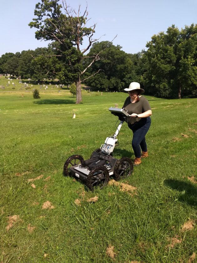
photo by: Contributed
Volunteer Henri Gaeddert helps to conduct a survey of the potter’s field at Oak Hill Cemetery, 1605 Oak Hill Ave.
NAACP project
The Lawrence branch of the NAACP has been working since 2019 with the Equal Justice Initiative, which created a national lynching memorial in Montgomery, Ala., to erect a historical marker at the site of the lynching.
As part of its reporting on the NAACP project in 2019, the Journal-World previously reviewed newspaper archives, letters from the time and other historical documents related to the lynching. According to those archives, in the summer of 1882, the body of David Bausman, who was white, was pulled from the Kansas River. Vinegar, King and Robertson were arrested in connection with his death, as was Vinegar’s teenage daughter Margaret “Sis” Vinegar. Pete Vinegar was never charged with a crime. Before a trial could take place, Vinegar, King and Robertson were lynched from a bridge over the Kansas River by a mob of men who broke into the jail in the middle of the night using sledgehammers and chisels.
According to accounts from the time, Bausman, who was in his mid-40s, had been having sex near the river with Margaret, who was only about 14 — statutory rape under current Kansas law — when King and Robertson came upon the scene and allegedly hit him over the head. Pete Vinegar was not present. Margaret was accused of conspiring with the other two men to rob Bausman, though her attorney argued there was no evidence whatsoever for that accusation. Though the mob decided not to hang Margaret, she was later convicted of murder and died from tuberculosis in prison while her attorney was in the midst of an effort to get her released, according to historical letters reviewed by the newspaper.
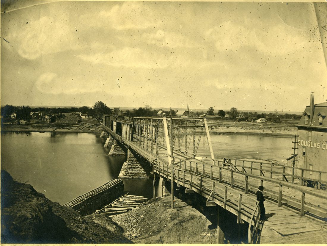
photo by: Watkins Museum of History
The old bridge across the Kansas River near downtown Lawrence is pictured in 1866. The bridge was used to lynch three black men in 1882.
The Lawrence NAACP’s project to commemorate the lynching, which has several components, was delayed by the coronavirus pandemic, but is moving forward again. Minor said entries for a student essay contest on racial justice history have been submitted and winners will be announced Tuesday.
Minor said the NAACP is nearing the end of the process to create a historical marker for the site of the lynching. The marker will be placed in an area just west of City Hall that’s in view of a stone pillar that remains from the bridge where the men were lynched. She said the NAACP and the Equal Justice Initiative previously agreed on the language of the marking as it relates to the lynching, and are now working on a section that commemorates Margaret, who Minor notes was also a victim.

photo by: Rochelle Valverde
Part of the old bridge across the Kansas River remains on the riverbank near downtown Lawrence. The old bridge was used to lynch three black men in 1882. Pictured Sept. 26, 2019.
Minor said a series of educational programming and discussions are being planned, and the first should hopefully be announced by the fall. She said plans are for that component of the project to begin with a small group discussion for African-American males, who as victims of police killings have been subject to a modern form of lynching.
“There is a form of lynching that’s happening today with the African-American community, and we want to talk about things comparing then and now,” Minor said.
Minor said other events would be open to the entire community, with the ultimate goal of better understanding the city’s past, which she hopes will improve its future. She said when she and Altenbernd first starting doing presentations about the lynching in 2019, many people who have lived in Lawrence most of their lives didn’t know about the lynching and were shocked.
“I think in order for our community to move forward, we have to get together and talk about these things and be aware of things that have happened in our community,” Minor said. “To be able to move forward you have to deal with what happened in the past.”
Minor said the Lawrence NAACP is working on a schedule of events for the project to commemorate the lynching that will be made available to the public once it’s finalized.
Other News

Douglas County Historical Society launches fundraiser after federal grant terminated by executive order; museums like Watkins fear future funding cuts

May Day protest in Lawrence and across the U.S. to oppose Trump’s executive actions and support workers’ rights, social justice

Uncover traces of the past at a ruined mansion in Lecompton this summer with the Kansas Archeology Training Program’s field school

Advocates fear potential Medicaid cuts could strip coverage from thousands of Kansans, threatening hospitals and health care access

Lawrence school district names new assistant principal at Free State High School
