Owyhee country full of natural beauty
Outdoor enthusiasts find plenty to like in undeveloped wildlands of Idaho
Boise, Idaho ? For nearly two centuries, a vast expanse in the corner of present-day southwestern Idaho and portions of neighboring states was considered a sagebrush wasteland of little interest.
But the adventurous are starting to find out about the Owyhee country, which features whitewater rivers rushing through deep gorges, juniper-covered peaks, multicolored geology and millions of acres of Old West solitude to experience.
It’s considered the largest undeveloped, unprotected wildlands in the lower 48 states.
“The area is such an amazing, undiscovered gem,” says Roger Singer, director for the Sierra Club’s Idaho chapter. “Relatively few people have found it yet. It’s just not on the map, which is good in a sense. The area has stayed relatively pristine, compared with our overdeveloped, loved-to-death national parks.”
Volcanic activity starting 14 million years ago created the largest concentration of rhyolite rock in the world. The immense Lake Idaho formed and later drained, slicing the gorges of the Owyhee, Bruneau and Jarbidge rivers.
Humans have been in the area for 15,000 years, including the Shoshone and Paiute tribes. In 1818, white trappers accompanied by several Hawaiians entered the region. The Hawaiians disappeared as they were exploring a river that was later named the “Owyhee,” the phonetic spelling for Hawaii at the time.
Basque sheepherders from Europe and cattlemen have worked the area since the 1800s. Miners sought gold and silver in the Owyhee Mountains beginning in the 1860s. They built communities like Silver City, a jewel of a ghost town near the Owyhee County seat of Murphy.
Vibrant ecosystems
Biologists consider the Owyhee to be one of the most biologically rich high-desert ecosystems in the country. It’s home to peregrine falcons, golden eagles, sage grouse, California bighorn sheep, pronghorn antelope, cougars and the rare redband trout.
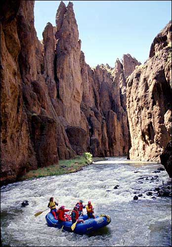
Rafters float along the Bruneau River in the Owyhee Canyon. Biologists consider the Owyhee to be one of the most biologically rich high-desert ecosystems in the country.
It also features native sagebrush and bunchgrass ecosystems, plus rare plants such as the Owyhee River Stickseed, Anderson’s buttercup and Inch-High Lupine.
The region has remained relatively untouched because access into the area was either via primitive roads, on foot or horseback. That is starting to change along the edges closest to the Boise Valley. Hunters, motorcyclists and all-terrain-vehicle riders are venturing farther and farther into the realm.
While much of the Owyhee is still untrammeled, conservationists, ranchers, county officials, off-road enthusiasts and others are meeting in a task force to determine its future.
Conservation groups endeavored to have the Owyhee-Bruneau Canyonlands designated as a 2.7 million-acre national monument. Yellowstone National Park encompasses 2.5 million acres.
Rivers run through it
Hundreds of miles of the Owyhee and Bruneau rivers, with all their forks, are under study for preservation under the federal Wild and Scenic River system. A big draw these days is rafting or kayaking down those desert rivers.
The Owyhee River flows west from headwaters in Idaho and Nevada into Owyhee Reservoir in Oregon. There are several stretches that can be run.
| The U.S. Bureau of Land Management in Boise offers information about visiting the area at www.id.blm.gov/.The rivers’ complexion and difficulty can change from day to day.Private guides operate on the rivers and can be contacted through the Idaho Outfitters and Guides Assn. at ioga.org. |
The Bruneau River is referred to by paddlers as the “Sistine Chapel” of all river canyons.
It runs through a gorge up to 800 feet deep with rocks that resemble Bryce and Zion national parks.
The rapids on the two range up to a perilous Class V, according to the water levels. The rivers can be navigable from late March through mid-June, although Idaho’s long-running drought narrows that window considerably. A number of private outfitters operate on the streams.
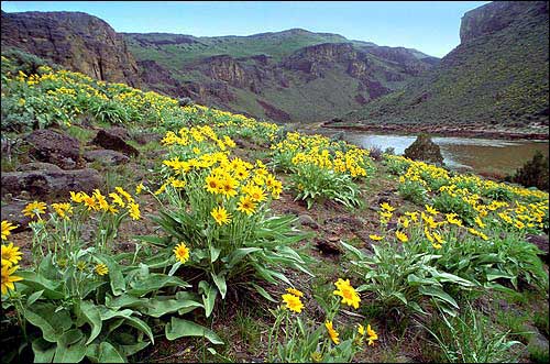
Wildflowers grow along the canyon of the Bruneau River, in the Owyhee country of southwestern Idaho.
Reaching the river put-ins, or other far-flung places in the Owyhee country, can be arduous or nearly impossible during spring rains.
“It’s for people looking for a different kind of adventure which requires route-finding skills, a hardy vehicle and a willingness to be out in the middle of nowhere,” Singer says.
| The best time to visit Owyhee country is in the dry season, from late spring into late October. Heavy rains can turn the unimproved roads into gumbo, trapping vehicles until a dry spell returns.It has historically been called the “Owyhee desert,” which can mean temperatures in the 100s from July into late September. The grass and sage are tinder-dry beginning in July. There are no mechanics or gas stations in the desert.Travel to the put-ins and take-outs of the Owyhee, Bruneau and Jarbidge rivers calls for truly rugged four-wheel-drive vehicles with an ample clearance to ease over lava rocks along the routes.Here are some more accessible spots to visit:Silver CityThis is a partially restored 19th-century mining town that once had a population of 3,000. The mining boom ended at the turn of the 20th century, but the town retains such beautiful buildings as the Idaho Hotel.The season for car traffic is June through November.Silver City is 70 miles southeast of Boise.Owyhee Uplands National Backcountry BywayThe 103-mile route offers high-desert scenery, including expanses of sagebrush, river canyons and white mesas. The route visits the North Fork of the Owyhee Canyon and western junipers more than 500 years old.Snow can block the road between October and early May. Cars with normal clearance can handle it in the summer.Jump Creek CanyonJump Creek cascades over several falls before dropping 60 feet into a pool. The canyon has a lush riparian area of water birch, dogwood trees and syringa. There are picnic facilities.From Boise take westbound Interstate 84. Take the Nampa exit to Highway 55 and go through Marsing, then 1.5 miles past the Highway 95 intersection, turn left onto Cemetery Road. Travel another 1.5 miles and turn left (south) on Jump Creek Road and head for the mouth of the canyon, which is visible in the distance. |