Local History: The Kansas River’s big flood — and the legacy it left
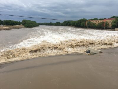
photo by: Kim Callahan
The Kansas River is pictured on Wednesday, June 1, 2022.
It’s often easy to forget about the Kansas River. If we drive over the bridge, we might notice whether the water level is high or low, whether there are sandbars or accumulations of driftwood, and speculate on whether the water is generating power via the dam. The river is there, but it doesn’t play a very visible role in our daily lives.
But occasionally, the Kansas River can be extremely visible — more visible than we want it to be.
In 1951, the Kansas River flooded, causing millions of dollars in damage and destroying homes and businesses. Historian David Dary, in his 1982 book “Lawrence Douglas County Kansas: An Informal History,” called it “the worst flood in Lawrence history, and one of the worst in the nation’s history.”
“Many residents of North Lawrence lost their homes and all their belongings,” Dary wrote. “Businesses were destroyed.”
If you want to picture how high the floodwaters got in the summer of 1951, go to the teepee structure near the intersection of Highways 24 and 40. You’ll see a 7-foot water line across the structure.
“That flood will be remembered for decades to come as the granddaddy of all great floods on the Kansas River since the founding of Lawrence,” Dary wrote.
How did such a flood happen? It started with record-breaking rainfall, which Dary said began in mid-June of that year.
“In Lawrence, 16.52 inches of rain fell between June 20 and July 13, representing almost half of a normal year’s precipitation,” Dary wrote.
There were actually two floods in less than a month. The river reached 25.6 feet on June 23, the highest since 1903. Three weeks later, the peak reading was 30.42 feet.
In the wake of the 1951 flood, many residents wanted to ensure that such destruction couldn’t happen again. They built dams and reservoirs on the streams feeding the Kansas River, Dary said, which “has greatly reduced the likelihood of another great flood like that of 1951.”
One of the most visible of these projects is Clinton Lake, but there are many other projects that have been built since the 1951 flood. These include projects in Kirwin and Webster in the 1950s; Tuttle Creek, Norton, Wilson, Council Grove, Cheney, Elk City, Milford, Marion and Glen Elder in the 1960s; Perry in 1970; and Big Hill, El Dorado and Hillsdale in the 1980s.
In “Soil of Our Souls: Histories of the Clinton Lake Communities” by Martha Parker and Betty Laird, we learn that Clinton Lake is filled by Deer Creek and Rock Creek and the somewhat larger Wakarusa River.
Washington Creek flows into the Wakarusa just below the dam. The book also documents the lives of the people who were displaced by Clinton Lake.
The Wakarusa River Valley Heritage Museum celebrates the heritage of these rural communities. It is located at 716 North 1190 Road and can be reached at (785) 783-4420.