
Snow will clear out this afternoon, but more on the way

Snow will clear out later today, but another system will bring even more snow chances by the end of the weekend.
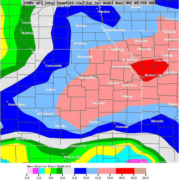
Here’s a look at the snowfall totals we’ve received across Northeast Kansas so far this morning. Let us know how much snow you received at your house. Before we start talking totals for this next batch of snow, let’s take guesses. How much snow do you think we’ll see with the next system? The image below is one computer model projection of snowfall totals for today’s storm and our next storm.
Osage County:
2.5″ Auburn
3.0″ Osage City
Washington County:
3″ Washington
2″ Clifton
4.5″ Haddam
Marshall County:
4.5″ Beattie
3″ Blue Rapids
3.0″ Marysville
2.5″ Lillis
3.5″ Marysville
3″ Oketo
Morris County:
2″ White City
1.5″ Wilsey
1.5″ Council Grove
Shawnee County:
2.5″ Silver Lake
2″ Topeka
2.5″ NE Topeka
2.5″ South Topeka
Pottawatomie County:
2.8″ Blaine
2.1″ Olsburg
Wabaunsee County:
2.4″ Eskridge
2.2″ McFarland
Cloud County:
1″ Clay Center
3″ Miltonvale
4.2″ Concordia
Geary County:
1 ” Milford Lake
Douglas County:
1″ Lecompton
3″ Clinton Lake
Riley County:
1.5″ Randolph
Brown County:
1.2″ Hiawatha
3″ Fairview
Lyon County:
2 ” Neosho Raphids
2″ Emporia
Jackson County:
4.2″ Meriden
3.5″ Holton
Jefferson County:
3.9″ Valley Falls
1″ Oskaloosa
1.5″ Perry Lake
Nemaha County:
4.5″ Baileyville