Dolly gains hurricane strength and aims for US-Mexico border
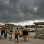
The Rocha family, from left, Chris, Marissa, 3, Christian, 9, and Letty, retreat to their vehicle at Padre Balli Park in Corpus Christi, Texas, as a band of rain moves in from the Gulf of Mexico on Tuesday. Forecasters say Hurricane Dolly was expected to dump 15 to 20 inches of rain and bring coastal storm surge flooding of 4 to 6 feet above normal high tide levels.
McAllen, Texas ? Dolly spun into a hurricane Tuesday, heading toward the U.S.-Mexico border and the heavily populated Rio Grande Valley, where officials feared heavy rains could cause massive flooding and levee breaks.
Dolly was upgraded from a tropical storm Tuesday afternoon, and sustained winds later reached about 80 mph. Some strengthening of the Category 1 storm was forecast before landfall today. At 10 p.m. CDT, the storm’s center was about 110 miles east-southeast of Brownsville, moving northwest at about 9 mph.
A hurricane warning is in effect for the coast of Texas from Brownsville to Corpus Christi and in Mexico from Rio San Fernando northward.
In Mexico, Tamaulipas Gov. Eugenio Hernandez said officials planned to evacuate 23,000 people to government shelters in Matamoros, Soto La Marina and San Fernando.
Texas officials urged residents to move away from the Rio Grande levees because if Dolly continues to follow the same path as 1967’s Hurricane Beulah, “the levees are not going to hold that much water,” said Cameron County Emergency Management Coordinator Johnny Cavazos.
The first bands of rain began to pass over South Padre Island Tuesday afternoon and the surf continued to get rougher. Intermittent heavy downpours began moving through Brownsville by late afternoon. Forecasters predicted Dolly would dump 15 to 20 inches of rain and bring coastal storm surge flooding of 4 to 6 feet above normal high tide levels.
Tropical storm warnings were issued for areas adjacent to the hurricane zone, and Gov. Rick Perry declared 14 South Texas counties disasters, allowing state resources to be used to send equipment and emergency workers to areas in the storm’s path.
The storm, combined with levees that have deteriorated in the 41 years since Beulah swept up the Rio Grande, pose a major flooding threat to low-lying counties along the border. Beulah spawned more than 100 tornadoes across Texas and dumped 36 inches of rain in some parts of South Texas, killing 58 people and causing more than $1 billion damage.
“We could have a triple-decker problem here,” Cavazos told a meeting of more than 100 county and local officials Tuesday. “We believe that those (levees) will be breached if it continues on the same track. So please stay away from those levees.”
Around Brownsville, levees protect the historical downtown as well as preserved buildings that were formerly part of Fort Brown on the University of Texas at Brownsville campus. Outside the city, agricultural land dominates the banks of the Rio Grande, but thousands of people live in low-lying colonias, often poor subdivisions built without water and sewer utilities.
Residents of northern Mexico were taking the impending storm in stride.
Blas Garica, a 62-year-old builder in Reynosa, was taping up his windows and putting sandbags in front of his porch to prepare.
“I’m not afraid because we flood frequently around here,” he said. “If my house floods, we’ll just run to the roof.”
In Reynosa, restaurants, businesses and maquilas, the import-export plants along the border, were also getting sandbags ready.
On South Padre Island, vacationers packed up their camps and headed for the mainland.
National

Kansas’ two Republican U.S. senators vote to pass Trump’s ‘big, beautiful bill’

Senate passes Trump’s big tax breaks and spending cuts bill as Vance breaks 50-50 tie

Supreme Court upholds Texas law aimed at blocking kids from seeing pornography online
Supreme Court says Maryland parents can pull their kids from public school lessons using LGBTQ books

Supreme Court limits nationwide injunctions, but fate of Trump birthright citizenship order unclear