Heading out to measure aquifer levels, crew expects to see some decline from previous year
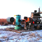
photo by: Kansas Geological Survey
Brett Wedel, a field research assistant, with the Kansas Geological Survey, checks a well east of Liberal on a previous January trip to measure groundwater levels.
Like clockwork, during the first week in January, a crew with the Kansas Geological Survey will make its annual trek west to measure groundwater levels in the High Plains Aquifer, one of the largest reserves of groundwater in the world.
“At some wells, we’ll arrive at the same hour we arrived the year before,” said Brownie Wilson, KGS support services manager, during a phone interview Thursday.
For 22 years, the KGS, based at the University of Kansas, in cooperation with the Kansas Department of Agriculture’s Division of Water Resources, has been monitoring the High Plains Aquifer, which includes the Ogallala Aquifer, an underground reservoir below eight states from South Dakota to Texas. They also monitor wells in central Kansas’ Great Bend Prairie Aquifer and in the Equus Beds, which provide water for the city of Wichita and which are also part of the High Plains Aquifer.
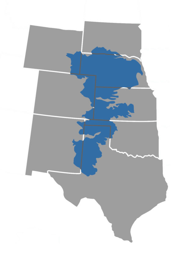
photo by: Sylas May
The Ogallala Aquifer runs through portions of eight states: South Dakota, Wyoming, Nebraska, Colorado, Kansas, Oklahoma, New Mexico and Texas.
“The High Plains Aquifer is relatively young in the geologic sense, as most estimates have it forming somewhere between 2 and 30 million years ago,” Wilson said. “It is the primary water source for most of western and central Kansas, supplying 70 to 80 percent of the water used in Kansas.”
Much of the Ogallala portion of the aquifer, located in the western third of the state has experienced steady water-level declines, as large-volume pumping is usually greater than the amount of water recharging the aquifer each year. Current research indicates that even though modest reductions in groundwater usage could greatly reduce the rates of water-level decline, full recovery of the aquifer to predevelopment levels would likely take decades to thousands of years, Wilson said.
Landowners know to expect the crew during the first week of the new year. At each well, crew members leave a tag with the current measurement and what the numbers have been the past several years.
They use a thin steel tape that burrows deep into the well to take the measurement. The distance down to the water in the Ogallala portion of the High Plains Aquifer varies greatly from near the land’s surface to more than 400 feet down in southern Haskell County between Garden City and Liberal, Wilson said.
While the 2018 data revealed a slowing in the decline of the water level, that might not be the case in 2019.
“The last couple years, we got above normal precipitation over the summer months, and there was some decline,” Wilson said. At the same time, there were wells where the water level was higher.
That was the case in an area between Garden City and Lakin, where heavy rains were reported. The water level from 2017 to 2018 was up 2 to 10 feet in some areas. That was in an area where there is a 33-mile canal system, known as the Amazon Ditch, used by farmers to divert water from the Arkansas River to their fields.
While levels had improved there in 2018, Wilson said it’s a unique area where water levels can fluctuate a lot.
“It’s the nature of the canal system and its high interaction with the underlying aquifer,” Wilson said.
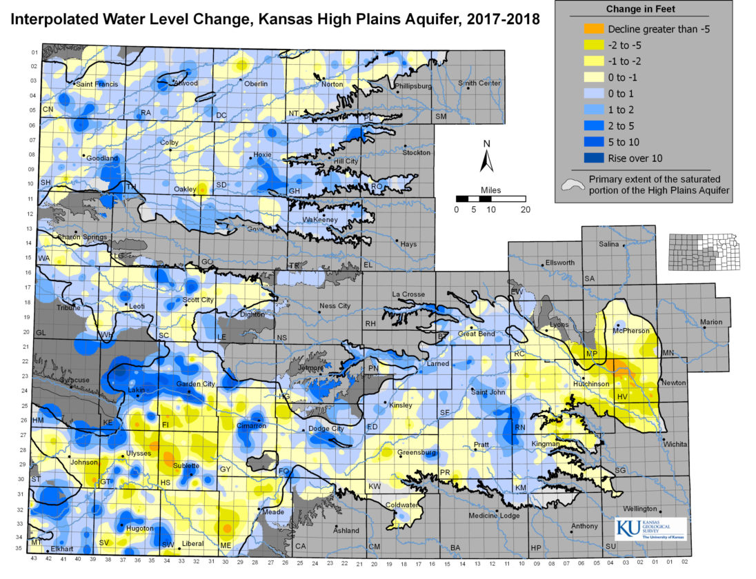
photo by: Kansas Geological Survey
Water level changes with the High Plains Aquifer 2017 to 2018
Wilson noted that same area, over a five-year period from 2013 to 2018, saw a decline of 10 to 30 feet in a cross-section of wells measured.
Kansas started 2018 in a drought. By March 27, the Kansas portion of the High Plains Aquifer was in a severe to exceptional drought, according to the U.S. Drought Monitor. However, conditions improved by midsummer with most of the region receiving rain.
“My guess is, this year. we will see declines,” Wilson said. “But not the way we saw great drops in 2011 and 2012.”
Wilson said that drop was not so much the influence of drought, but the fact that precipitation influences the pumping demands.
“So if it’s dry, they are pumping more and it accelerates the groundwater decline,” Wilson said.
The groundwater level in much of western Kansas has dropped as pumping increased over the past 70 years. Declines in some areas, especially southwest Kansas, accelerated in the early 2000s when prolonged drought conditions led to increased pumping, according to a news release from KGS.
Once the week of measuring is completed, Wilson said they would try to get the raw data online as soon as they could, usually by the end of February. Wilson said the information was used for a variety of things, including determining whether water management policies were making a difference. The raw 2018 field measurements can be viewed on the KGS website.
KU

KU faculty members overwhelmingly approve formation of union; they will seek improvements in pay, job security

Last living witness to the abduction of Emmett Till tells KU crowd it is important that the story lives on

About 150 bills in statehouses across the country, including Kansas, focus on diversity, equity changes

KU announces 2 more candidates for vice chancellor of research position

Leading civil rights attorney tells KU crowd that Brown v. Board decision must be defended, better used
COMMENTS