All watches and warnings canceled for Douglas County
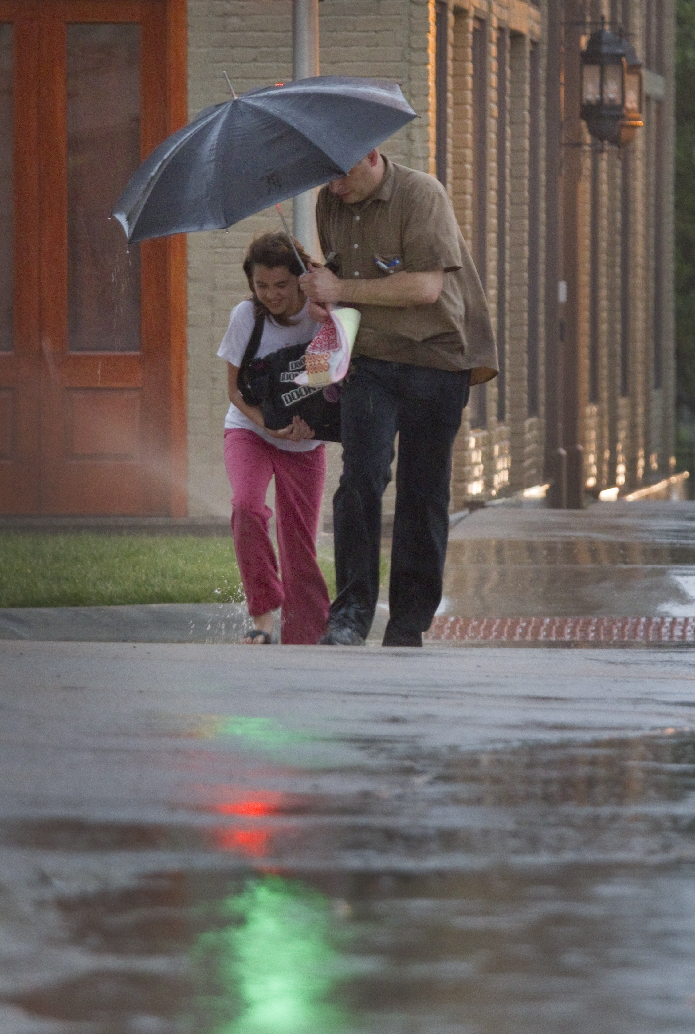
Heavy rains moved through the area Tuesday afternoon, which made walking along 8th Street a bit of a chore for Ella Denson-Redding and her father, Douglas Redding, both of Lawrence.
8:47
The flash flood warning has also been canceled early in Douglas County.
There are no active watches or warning in Douglas County.
8:43 p.m.
The National Weather Service has canceled the tornado watch for Douglas County about 20 minutes early.
The flash flood warning remains in effect until 9:30 p.m. for Douglas County and surrounding areas.
Check LJWorld.com for updates.
8:19 p.m.
The tornado watch for Leavenworth, Jefferson and Wyandotte Counties has been ended.
Douglas County remains under a tornado watch until 9 p.m.
6:18 p.m.
Lisa Rueschhoff found herself in for quite a shock about 5:40 p.m. Tuesday evening, mere moments after settling in to watch a little TV.
“We were just sitting there, turning on the news to watch the weather, when we heard the loudest thunder ever — just smashing,” she said, outside her home on Carmel Place in western Lawrence. “I thought the picture window busted out in our living room.”
Turns out lightning had struck the peak of her home, sending a bolt of energy through the walls.
“The light swtiches in our dining room just shattered into our kitchen area,” she said. “They just blew apart. … It’s just amazing to me that something like this could happen.”
As expected, the home’s alarm system immediately delivered a message to the monitoring company — all associated with Rueschhoff Locksmith and Security — and spurred a call from a company representative: Are you OK?
Yes, Rueschhoff had said. And as neighbors soon gathered outside, and a Lawrence-Douglas County Fire & Medical crew showed up to check for problems, she would feel fortunate to have her health.
“It’s pretty scary,” she said,” “but all is well.”
6:15 p.m.
The tornado warning for Franklin County has been allowed to expire.
The tornado watch and flash flood warning remain in effect.
6:13 p.m.
Westar Energy now reports three customers without power, all in rural Douglas County.
The utility no longer reports any Lawrence customers without power.
5:52 p.m.
The National Weather Service in Topeka has issued a Tornado Warning for Franklin County until 6:15 p.m.
At 5:47, National Weather Service radar indicated a storm capable of producing a tornado was located 17 miles southwest of Ottawa.
The storm was moving east at 25 mph.
5:45 p.m.
About 173 Douglas County Westar Energy customers are without power at this hour.
According to the Westar website, the outage is concentrated in the area of Bob Billings Parkway and Crestline Drive.
5:39 p.m.
The National Weather Service in Topeka has issued a flash flood warning for Douglas County until 9:30 p.m.
The flash flood warning also covers Johnson, Franklin and Osage counties, which have born the brunt of the rain thus far.
Radar indicates very heavy rain occurring from thunderstorms across the area, with one to two inches already fallen and an additional one to two inches possible through 7 p.m.
Witnesses report flooded conditions along Massachusetts Street, 19th Street, Haskell Street, 18th Street at Tennessee Street, Iowa Street at 9th Street and 9th Street between Iowa and Michigan.
Remember, turn around, don’t drown, and don’t drive into high water.
5:33 p.m.
We’ve started getting reports of high water around town. So far, witnesses have reporter high water at the intersection of 9th and Iowa streets and 18th and Tennessee streets.
Remember, turn around, don’t drown, and don’t drive into high water.
5:15 p.m.
The tornado warning for Osage County has been allowed to expire because the rotation has weakened.
The severe thunderstorm warning in the Kansas City area has also expired, however a flash flood warning is in effect. Heavy rains have prompted reports of flooding in northeast Kansas, especially in the Kansas City area, where some streets are covered with more than 6 inches of rain.
Heavy rain was just beginning to fall in Douglas County.
The National Weather Service reminds motorists not to drive into standing water as it can sweep you away.
4:52 p.m.
A tornado warning has been issued for Osage County and Coffey County, southwest of Douglas County. National Weather Service radar indicated a storm capable of producing a tornado was moving through the area.
The National Weather Service also issued a severe thunderstorm warning for portions of Johnson and Miami county in the Kansas City-metro area.
Also, NOAA Weather Radio is out of commission in the Kansas City area. Kansas City residents are urged to stay in contact with local media for the duration of the severe weather.
3:17 p.m.
Matt Elwell, 6News meteorologist, said thunderstorms will form along a cold front surging through the area.
“The main concerns are for large hail, and damaging wind with the chance of isolated tornadoes forming with some of the larger storms,” Elwell said. “The fact that the lowest part of the atmosphere has an abundance of moisture means that many of these storms will be low-based and easier for tornadoes to form.”
Elwell said the storm threat should decrease as sundown approaches, once the cold front passes.
Read more about today’s severe weather at our weather blog.
2:43 p.m.
The National Weather Service in Topeka has issued a tornado watch for Douglas County and six surrounding counties.
It means conditions are favorable for severe weather, which could include the development of tornadoes.
The watch is in effect until 9 p.m. for these counties: Douglas, Franklin, Jefferson, Leavenworth, Osage, Shawnee and Wyandotte.
9:05 a.m.
The severe thunderstorm watch has been allowed to expire at 9 a.m., though rain and some thunderstorms remain in the area.
There’s another chance for severe weather — some hail, damaging winds and possibly tornadoes — later this afternoon.
Stay with LJWorld.com for updates.
2:13 a.m.
The National Weather Service has issued a severe thunderstorm watch for Douglas County and surrounding counties until 9 a.m. Tuesday morning. Franklin and Jefferson counties are included in the watch.
Storms could develop west of Lawrence with winds as strong as 75 miles per hour. Heavy rainfall and hail the size of quarters is also possible.
More storms are likely to develop Tuesday afternoon, according to the NWS.
Check back with LJWorld.com for more updates as they are available.