City continues street plowing overnight; Wind chill advisory replaces blizzard warning
Send us your photos!
Taking pictures of Tuesday’s storm? Send them our way and we’ll feature them on LJWorld.com, Facebook and Twitter.
Log in to LJWorld.com with your free user account (or create one here) and start uploading!
The U.S. National Weather Service is predicting 9-13 inches of snow for Douglas County by Wednesday.
8:37 p.m. update
The National Weather Service in Topeka has canceled the blizzard warning for Douglas, Jefferson, Shawnee and Franklin counties.
In it’s place, the weather service issued a wind chill advisory, in effect until noon Wednesday.
The blizzard warning continues for area to the east, including Johnson and Leavenworth counties, though it too is expected to end soon and be replaced with a wind chill advisory.
8:10 p.m. update
Lawrence crews are continuing plowing operations overnight and hope to have all priority one and two routes in Lawrence treated by morning.
For Tuesday night, though, the city has just one message: Stay inside.
“At this time, I want to strongly encourage everyone to stay home and do not get out unless it is an emergency,” Gilliland said. “Our street crews’ priority is to clear the streets; vehicles that get stuck just create another impediment and we want people to get home and stay home where they are safe.”
At that point, the city will move into residential neighborhoods. According to a statement from city communications manager Megan Gilliland, the city will call on outside contractors and other city departments on Wednesday to help with clearing operations. The city expects to work on downtown and residential streets at some point on Wednesday.
Also, the city said garbage collection would go on as normal on Wednesday, though delays are possible. Crews may have to bypass some areas, but Gilliland said crews would visit those areas on Thursday.
Customers can call in missed areas to (785) 832-3032.
7:45 p.m. update
T bus service hopes to run at 8 a.m. Wednesday. A previous update erroneously said it would not run until Thursday.
6:40 p.m.
As of 6:40 p.m., virtually all local schools have called off Wednesday classes, including Lawrence public schools and Haskell Indian Nations University.
Douglas County Emergency Management officials reported 8 inches of snow has fallen in downtown Lawrence, but the snow continues falling.
The National Weather Service predicted between 9 and 13 inches of snow from this storm, so it looks like this will be on the lower side. Still, at 8 inches, this will be the largest snow storm to hit Lawrence in 20 years.
5:26 p.m.
We have our first official snow reports from the National Weather Service: 10″ in Eudora and 6.5″ east of Lawrence. Those reports are somewhat old, and the snow continues to fall.
Also, Kansas University has officially canceled classes on Wednesday. Only essential campus employees are required to report to work.
5 p.m. update
We’ve got a few closings for people who work second or third shift at different businesses around town, like Del Monte and Berry Plastics. Employees should check our complete closing list for exact details.
We also have some closings — plus some school districts, but not Lawrence — for tomorrow already.
Keep checking our closing lists for updates all night long.
4:29 p.m. update
Gov. Sam Brownback has ordered state offices in Topeka to be shutdown on Wednesday — for a second consecutive day.
Legislative leaders also agreed to suspend their activities for another day and will not be in session on Wednesday.
According to the National Weather Service, more than 6 inches of snow had already fallen across northeast Kansas, and it was still coming down.
Brownback urged Kansans to stay home.
3:25 p.m. update
The Missouri Department of Transportation has closed I-70 in many areas across the state of Missouri.
According to the Kansas Turnpike Authority, the Kansas Turnpike is passable from Topeka to Kansas City.
The Kansas Department of Transportation, however, implores all drivers to stay off the road until the storm passed.
3:10 p.m. update
Winds are picking up and large snowflakes are falling across Lawrence right now.
This is one of the heavy bands of snow predicted with this storm, which were expected to drop anywhere from 1 to 2 inches of snow per hour.
According to emergency officials, street crews are having a very difficult time keeping the roads in drivable conditions.
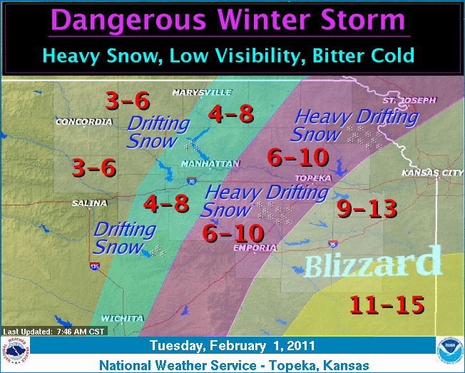
The latest information from the National Weather Service predicts 9 to 12 inches of snow will fall in Lawrence by the time the storm stops.
1:57 p.m. update
Lawrence municipal offices will be closing at 2 p.m. today, because of the inclement weather.
‘T’ bus service will run until 4 p.m., but may run behind because of the accumulation of snow on the roads. ‘T’ service will not resume until 8 a.m. Wednesday.
City crews will continue sanitation and street clearing operations, as well as other basic municipal services.
Roads are very treacherous. Even major streets are snowpacked and travel is difficult. Blowing and drifting snow has made accessing residential streets particularly challenging.
1:10 p.m. update
City leader are considering suspending or reducing the city’s T bus service today, because of the snow.
Chad Lawhorn has a report on the options the city is considering.
The city hopes, at the very least, to keep two buses running until 6 p.m. in order to pick up anyone who may have taken the T to work.
12:30 p.m. update
Reports from law enforcement indicate roads are becoming treacherous.
At least one motorist got stuck on Clinton Parkway and a semi-truck became stuck on Iowa Street at 19th Street. Police were blocking traffic at 19th and 21st streets in order to allow the truck to get moving again.
Crews were beginning plowing operations, which typically starts when about 3 inches of snow has accumulated on the ground.
We’ve put together a photo gallery of the biggest snow storms in the past 20 years. It includes storms from 1993, 1996, 2000, 2005 and 2009.
11:45 a.m. update
The U.S. Army Corps of Engineers has closed the road over the Clinton Lake Dam, citing blowing and drifting snow.
The road beneath the dam will remain open at this time.
11:07 a.m. update
Gov. Sam Brownback has signed a disaster declaration for the state of Kansas.
The declaration activates emergency actions and authorizes state resources for assistance statewide.
Fifty-three counties, including Douglas County, are named in the declaration as areas likely to be affected.
10:25 a.m. update
Heavy snow has started falling in Lawrence, and the wind is picking up.
Major Lawrence city streets are still passable, but quickly becoming less so. Residential streets are snowpacked. Though the snow is stronger now than it was earlier, the worst conditions of the day are expected in the afternoon. Crews are treating primary and secondary streets continuously. The city said it may not get to residential streets again until Thursday.
Lawrence residents are encouraged to get to their final destination by noon and to avoid the streets if at all possible after that time.
The latest update from the National Weather Service still calls for 9 to 13 inches of snow in the Douglas County area, as well as points east and northeast.
Snow is expected to fall from now until sometime overnight Tuesday.
8:55 a.m. update
According to a statement from the city, Lawrence solid waste crews are still operating. Both commercial and residential areas are currently being collected, though expect some delays due to slick conditions.
7:55 a.m. update
As of 7:30 a.m., KDOT is reporting that all highways in Douglas County are completely snowpacked:
- Kansas Highway 10
- Kansas Highway 32
- U.S. Highway 24
- U.S. Highway 40
- U.S. Highway 56
- U.S. Highway 59
Lawrence road crews are currently treating priority roads with sand and salt. Though snow has started falling, plowing operations will not being until snow accumulates on roads.
- Download a map of Lawrence “Priority 1” sand/salt routes
- Download a map of Lawrence snow plow routes
6:02 a.m. update
Kansas University’s Lawrence campus and Haskell Indian Nations University will both be closed on Tuesday, Feb. 1, 2011 due to the incoming storm.
Only weather-essential employees must report to work at KU.
Keep checking our list of closings and cancellations throughout the day.
4:26 a.m. update
Light snow has started to fall in Lawrence, and is expected to continue through Wednesday morning. A blizzard warning remains in effect until 6 a.m. Wednesday.
Snowfall will become heavy by noon, and strong winds of 20-30 mph with gusts of 35 mph will produce blizzard conditions with significant blowing and drifting snow.
Tuesday night expect a wind chill of 10-15 degrees below zero.
11:55 p.m. update
Lawrence and area schools have closed, along with many day cares and local businesses.
So far very few flurries have been reported in Lawrence, but winds are starting to pick up to more than 20 miles per hour. That wind is expected to get stronger as Tuesday progresses with gusts up to 35 miles per hour.
Temperatures have dipped to 16 degrees and have caused some slick streets and roadways. Temperatures could fall to as low as 12 degrees by early Tuesday with wind chills reaching 15 to 25 degrees below zero by Tuesday night, according to the National Weather Service.
5:04 p.m. update
With the snow storm impending, Gov. Sam Brownback has ordered state offices in Shawnee County closed on Tuesday.
Non-essential state employees in Topeka will have the day off. A decision about Wednesday will be made later. The state legislature has also suspended it’s activities on Tuesday.
Check out all of our closings over at our closing page.
3:09 p.m. update
The National Weather Service has issued a blizzard warning for the following counties:
- Anderson
- Coffey
- Douglas
- Franklin
The blizzard warning is in effect from 6 a.m. Tuesday through 6 a.m. Wednesday. An earlier blizzard warning also included Johnson, Leavenworth and Wyandotte counties.
Areas of freezing drizzle will continue through Monday evening before changing to snow by Monday night. Expect heavy snowfall Tuesday morning through late Tuesday night with total snow accumulations of 10-14 inches.
2:28 p.m. update
The National Weather Service has issued its strongest winter weather warning for counties just north and east of here: Johnson, Leavenworth and Wyandotte counties have all been placed under a Blizzard warning, from 6 a.m. Tuesday to 6 a.m. Wednesday.
A blizzard warning is issued when heavy snow and high winds are expected over an area for a prolonged period of time. A foot or more of snow is expected across the warned area, with winds blowing sustained between 25 and 40 mph. White out conditions are expected and drivers are urged to use caution if they must leave their homes.
The blizzard warning was issued by the National Weather Service in Kansas City, which does not cover Douglas County. The National Weather Service in Topeka, which does cover Douglas County, has not yet issued a blizzard warning in its area.
2:09 p.m. update
Power has been restored to over 350 customers in Douglas County after an equipment failure caused an outage in east Lawrence.
According to Westar Energy, the power was out from 12:01 p.m. to 1:57 p.m.
1:50 p.m. update
Westar Energy’s website is showing over 350 customers without power in Douglas County. The outage is concentrated in east Lawrence.
A piece of equipment failed near Ninth and Connecticut streets, according to Westar Energy representative Nick Bundy, and power should be restored soon.
9:51 a.m. update
Lawrence street maintenance crews began working 24-hour shifts at midnight Monday, according to a press release from the city. Crews have pre-treated all roads in Lawrence, including residential streets.
City officials said that although they will be staffed around the clock, the storm will still cause problems for drivers.
“Stay off the roads if you don’t need to be out,” said Tom Orzulak, street division manager. “I would also like to get the word out to University students to move their cars off the roads if possible and take the bus instead of driving and risk getting stuck.”
If Lawrence receives the amount of snow expected, crews will not focus on residential streets until main routes are plowed. City officials said it’s likely residential streets may not be plowed until Thursday or later.
- Download a map of Lawrence “Priority 1” sand/salt routes
- Download a map of Lawrence snow plow routes
9:14 a.m. update
K-10 has reopened at the Douglas-Johnson County line after being shut down both directions so road crews could treat the highway.
9:01 a.m. update
Kansas Highway 10 at the Douglas-Johnson County line is being shut down both directions until road crews can treat the asphalt. Multiple slide-offs were reported in that area (near Evening Star Road) Monday morning.
Here are the conditions of highways in Douglas County as of 7:15 a.m. according to KDOT:
- Interstate 70 — Partly snowpacked/Ice
- Kansas Highway 10 — Wet/Slush
- Kansas Highway 32 — Wet/Slush
- U.S. Highway 24 — Wet/Slush
- U.S. Highway 40 — Wet/Slush
- U.S. Highway 56 — Wet/Slush
- U.S. Highway 59 — Wet/Slush
5:55 a.m. update
As of early Monday morning, the Kansas Department of Transportation was reporting good road conditions throughout Douglas County, though the winter storm warning remains in effect until 6 a.m. Wednesday.
We’ll mostly see freezing drizzle before snow begins Monday evening. Ice accumulations are expected to be up to a tenth of an inch.
Additionally, the first school closing of the storm is in. Santa Fe Trail USD #434 has canceled classes for Monday, Jan. 31, 2011. We’ll keep updating closings and cancellations for Monday here.
1:50 a.m.
There are no flurries as of 2 a.m., though there are reports of freezing drizzle in the area. More freezing precipitation is expected through the early morning hours, which could cause slick, dangerous road conditions.
According to the National Weather Service, up to a tenth of an inch of ice could accumulate by Monday evening. Conditions are expected to deteriorate rapidly Monday night and into Tuesday as heavy snow combines with blustery winds to create extremely hazardous road conditions.
Check back with LJWorld.com for continued weather updates as well as school and event cancellation information throughout the day.
8:32 p.m. update
According to most recent reports from the National Weather Service, the most snow should accumulate east of Topeka — possibly more than 10 inches.
About 5-7 inches of snow is projected to fall west of Marysville and Herington, and another 7-9 inches is possible elsewhere.
Snow is expected to develop Monday night over northeast Kansas and should end across the entire state Wednesday morning.
4:11 p.m. update
The National Weather Service has now issued a winter storm warning for Douglas and surrounding counties. The warning is effective from midnight Sunday to 6 a.m. Wednesday.
Freezing drizzle and light freezing rain will develop late Sunday night into Monday before changing over to snow Monday night. Snowfall is expected to continue through Tuesday night, with 8 to 12 inches of accumulation expected.
Strong winds are also expected to accompany the winter storm on Tuesday, which may lead to blowing and drifting snow, which could lead to even higher snow depths.
Bitter cold wind chills of -15 to -25 are also expected after the snow ends.
The following counties are included in the warning:
- Anderson
- Brown
- Coffey
- Dickinson
- Douglas
- Franklin
- Geary
- Jackson
- Jefferson
- Johnson
- Leavenworth
- Lyon
- Marshall
- Morris
- Nemaha
- Osage
- Pottawatomie
- Riley
- Shawnee
- Wabaunsee
- Wyandotte
Travel during the storm will become difficult, if not impossible, as roads become extremely hazardous. Residents are advised to prepare to remain at their homes throughout the storm and not to go out except in the most severe emergencies.
11:45 a.m. update
Latest weather map from the National Weather Service in Wichita shows area between Topeka and Kansas City, including Lawrence, have the “best chance” to receive more than five inches of snow Monday night into Tuesday morning. A region southeast of Lawrence, including portions of southeast Kansas and western Missouri, could receive more than eight inches of snow, according to the weather map.
7:30 a.m. update
A winter storm watch is still in effect from late Sunday night through late Tuesday night, according to the National Weather Service.
Freezing rain is expected to develop tonight and continue until Monday evening. By Monday night, snowfall is forecasted to begin and continue through Tuesday night. Six to nine inches of snow accumulation is possible by Tuesday night.
3:30 p.m. Saturday
The National Weather Service has issued a winter storm watch for Douglas and surrounding counties effective late Sunday night through Tuesday night.
Freezing drizzle or freezing rain is expected to begin Sunday night and will change to snow by early Tuesday morning. Six to eight inches of snow accumulation is possible by Tuesday evening. Ice accumulation could also reach one-tenth of an inch by Monday night.
The NWS also warns of wind gusts up to 35 mph, which combined with heavy snowfall on Tuesday could decrease visibility and impact traveling conditions. Temperature forecast for Sunday night includes a low in the 20s, but wind chills could also drop to 15 degrees below zero on Tuesday evening.
The area counties included in the watch are:
• Douglas
• Johnson
• Franklin
• Leavenworth
• Wyandotte
• Jefferson
Check back with LJWorld.com for updates.
City Government

City of Lawrence ‘assessing options’ in the wake of racist and antisemitic hate speech shared at recent commission meeting

City of Lawrence campsite reporting form has received 230 reports since October; only 57 campsites confirmed

City Commission meeting interrupted by racist, antisemitic hate speech

Lawrence City Commission set for light agenda this week

Campers who remain at North Lawrence site after closing date will be trespassed, but city doesn’t expect that to happen
