KU plane maps tornado’s destruction
Kansas Biological Survey program offers online images of Greensburg after May 4 storm
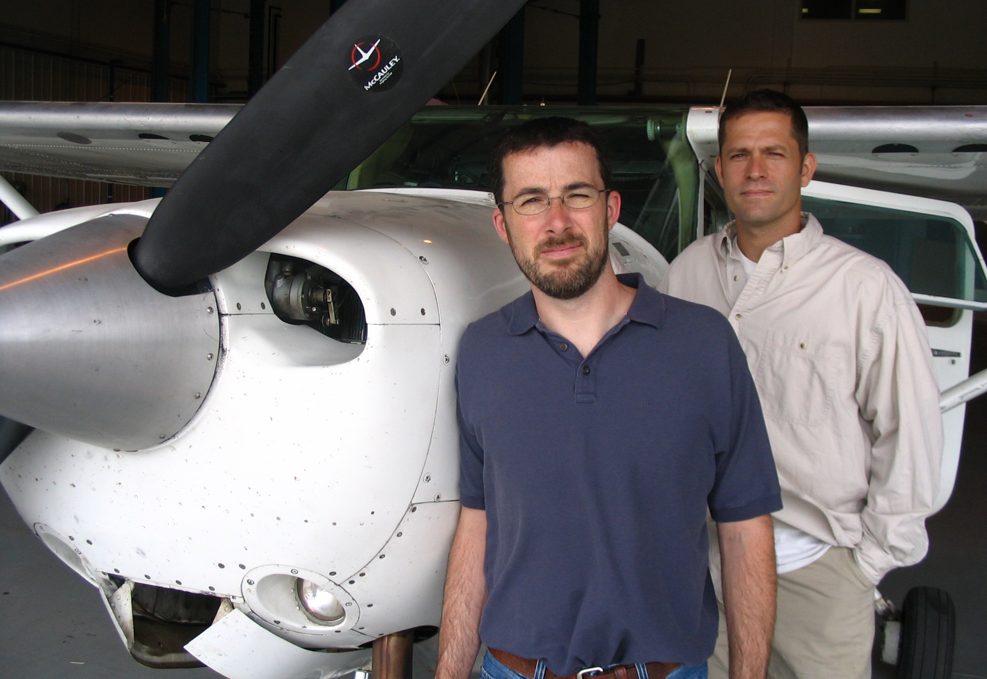
Mike Houts, left, and Kevin Dobbs, employees of the Kansas Biological Survey at Kansas University, have been working on gathering and processing high-resolution aerial photos of Greensburg since a tornado destroyed the town. In the aftermath of the tornado that hit Greensburg on May 4, the Kansas Applied Remote Sensing Program, a research unit within the Kansas Biological Survey, deployed KU's Cessna 182, equipped with a research-grade aerial imaging system, to Kiowa County to collect images. They can be seen online at www.kars.ku.edu.
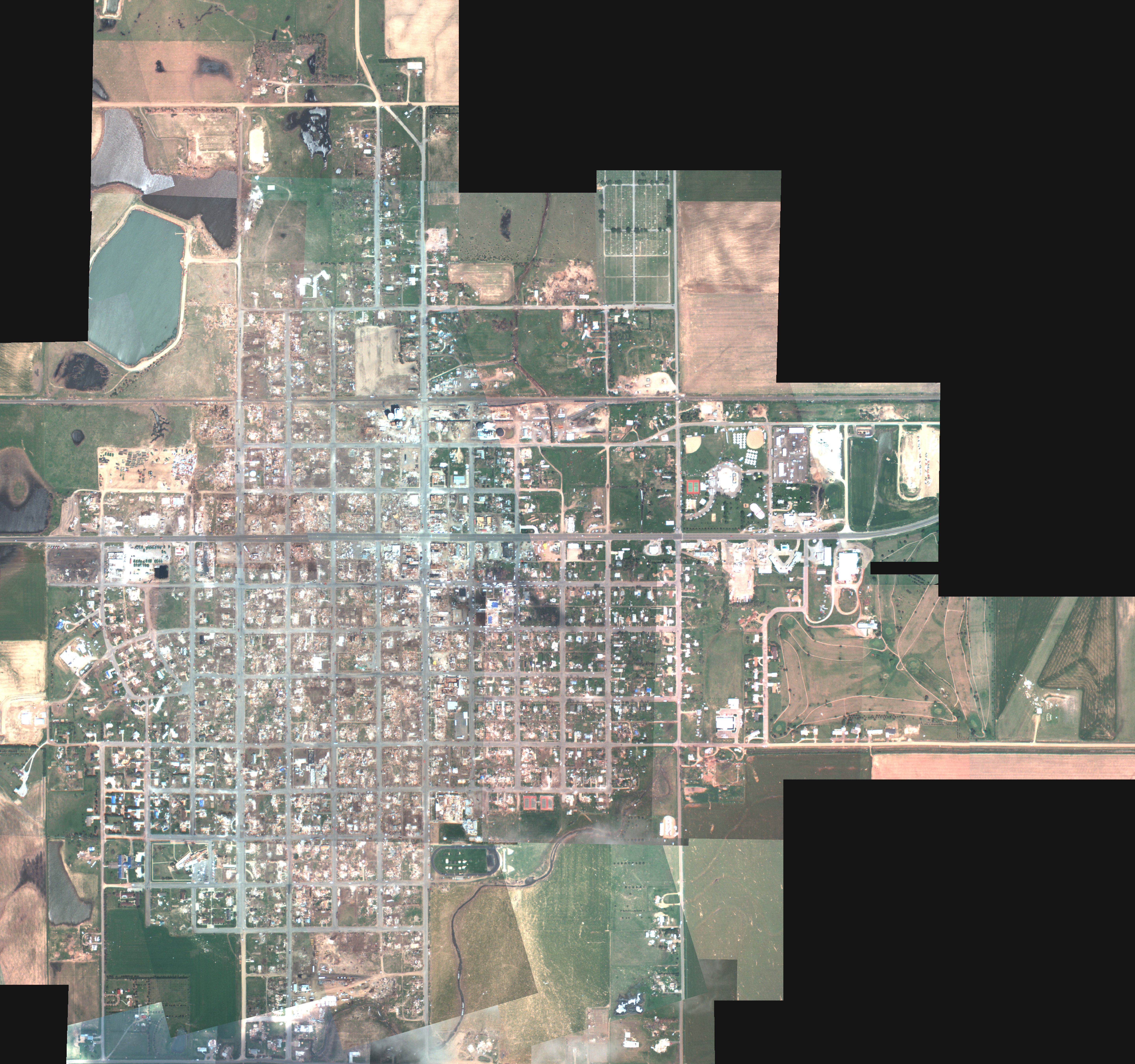
This is a Natural Color Mosaic of Greensburg taken May 14 by the Kansas Applied Remote Sensing Program. More aerial images of Greensburg can be found at www.kars.ku.edu.
Several Kansas University researchers are providing a bird’s-eye view of Greensburg, the Kansas town wiped out by a tornado early this month.
A team from the Kansas Applied Remote Sensing Program, part of the Kansas Biological Survey, spent about an hour flying over Greensburg on May 14 in a two-seater Cessna 182. The plane has a softball-size hole cut in the bottom and is equipped with a roughly $30,000 camera and computer system to take high-resolution aerial photographs.
“From the air, you really just see the full extent of everything. You can take in the whole picture at once and just see the sheer size of the destruction that happened,” said Mike Houts, a research assistant with the Kansas Biological Survey who rode in the plane.
The result is a set of digital maps – or “geospatial data” in scientists’ terminology – showing the town at the detail level of roughly one pixel per 1.5 feet. Houts said it was the most complete aerial mapping of Greensburg since the tornado hit.
KU put the images online so that government agencies, private companies and anyone else can download them and overlay them with other data, such as the location of underground storage tanks or property lines.
Kevin Dobbs, a Kansas Biological Survey employee who worked to assemble and publish the maps, said they were downloaded roughly 300 to 400 times in the first week they were online. He said he knew the Kansas Department of Health and Environment was interested in using the images to coordinate waste disposal, but other than that he’s not sure exactly how they’ll be used.
“We made it available to anybody who wants to use it,” he said. “We didn’t want to create any barriers.”
KU has used the plane for about seven years, mainly to map vegetation at places including Yellowstone National Park and Fort Riley. The camera shoots images in normal color and in infrared, which causes green plants to stand out in contrast to other materials.
The Greensburg trip cost about $3,000 and was paid for through the Kansas Geographic Information Systems Policy Board, a division of the state’s Department of Administration.
Greensburg tornado
- Greensburg mayor resigns (05-27-07)
- Governor signs $32M aid bill for tornado-stricken Greensburg (05-26-07)
- Greensburg claims to top $153 million (05-25-07)
- KU, arts center collect Greensburg aid (05-22-07)
- Going home to Greensburg (05-22-07)
- Lending a helping hand (05-22-07)
- Lawrence residents pitch in after Greensburg tornado (05-20-07)
- Donation of tubs runneth over (05-15-07)
- KU Dining Services donates to relief effort (05-15-07)
- Greensburg looks past cleanup, sees bright future for town ahead (05-13-07)
- More volunteers head to Greensburg (05-12-07)
- KU storm chaser’s video gets international play (05-09-07)
- Devastation and disbelief (05-06-07)
State Government

Kansas’ governor vetoes tax cut package over its costs; some fellow Democrats backed it

Kansas delegation split on votes to send $95B in aid to Ukraine, Israel and other allies

About 150 bills in statehouses across the country, including Kansas, focus on diversity, equity changes

New federal rule bars transgender school bathroom bans, but it likely isn’t the final word
A new, stable fiscal forecast for Kansas reinforces the dynamics of a debate over tax cuts
TOPEKA — The picture for tax cuts in Kansas and the next state budget remained stable Friday with the release of ...
