City, county look ahead to Lawrence’s next stages of growth
Southern, southeast areas of town looked at for new development
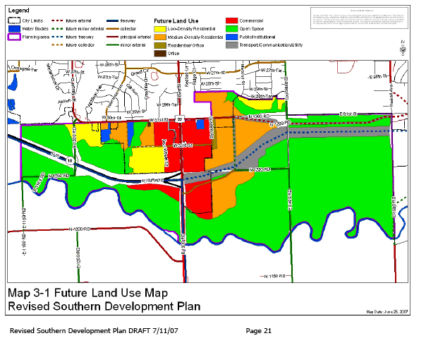
This map of proposed development in southern Lawrence would designate much of the area around the Wakarusa River as open space within the 100-year floodplain. It also envisions commercial areas along U.S. Highway 59, south of 31st Street; low- and medium-density residential developments would fill in much of the rest of the space between 31st Street and the Wakarusa River.
Two drafts plotting future development around south and southeastern Lawrence are being well-received by city and county leaders.
A few city and county commissioners met Wednesday morning to review the plans with the Lawrence-Douglas County Planning Commission and the planning staff.
The southern plan designates much of the area around the Wakarusa River as open space within the 100-year floodplain. It also envisions commercial areas along U.S. Highway 59, south of 31st Street; low- and medium-density residential developments would fill in much of the rest of the space between 31st Street and the Wakarusa River.
“I do like what I see,” City Commissioner Mike Dever said. “Although they are just colors and shapes on a map right now, I have looked over that area and tried to match up with what is currently there and what is proposing to be there and I think that is important. You look at current land before you start dictating future land use.”
The southern development plans includes mostly areas south of 31st Street. The southeast area plan covers an area between O’Connell Road and East 1750 Road – mostly industrial and multi- and single-family residential uses.
The planning commission will go over the proposals and once approved they will be forwarded to the city and county commissions.
The maps and the proposals for the southern plan can be found online at www.ci.lawrence.ks.us/planning/ which is the planning department’s Web site. The southeastern plan is not yet available online.
City Government

City of Lawrence ‘assessing options’ in the wake of racist and antisemitic hate speech shared at recent commission meeting

City of Lawrence campsite reporting form has received 230 reports since October; only 57 campsites confirmed

City Commission meeting interrupted by racist, antisemitic hate speech

Lawrence City Commission set for light agenda this week

Campers who remain at North Lawrence site after closing date will be trespassed, but city doesn’t expect that to happen
